.png) RHODESIAN SECURITY FORCES
RHODESIAN SECURITY FORCES
RHODESIAN SECURITY FORCES
RHODESIAN SECURITY FORCES
Maps of Rhodesia and Area
|
Map
(Click on map to view larger image_ |
Description |
|
Details Creator: Shell Title: Shell Road Map, The Federation of Rhodesia and Nyasland Notes: First Edition: May 1957. Published by Shell Company of Rhodesia Ltd. Format: PDF Size: 433 MB |
|
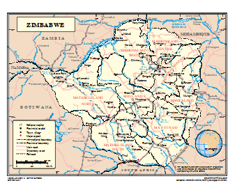
Details Creator: Unknown Title: A Political map of Zimbabwe 2002 Format: JPG Size: 235 kb |
|
Details Creator: Unknown Title: MAP Showing the position of SOUTHERN RHODESIA in relation to other parts of the world, and the routes by which the Country can be reached. Format: JPG Size: 6.8 mb |
|
Details Creator: Newspaper Archive Photo Title: Ceasefire Monitoring Agreements for the Patriotic Front Forces Map Format: JPG Size: 9.8 mb |
|
Details Creator: Department of Field Support Geospatial Information Section (formerly Cartographic Section) Title: UN General Map of Zimbabwe 2017 (Map No. 4210 Rev. 2 UNITED NATIONS December 2017) Format: PDF Size: 680 kb |
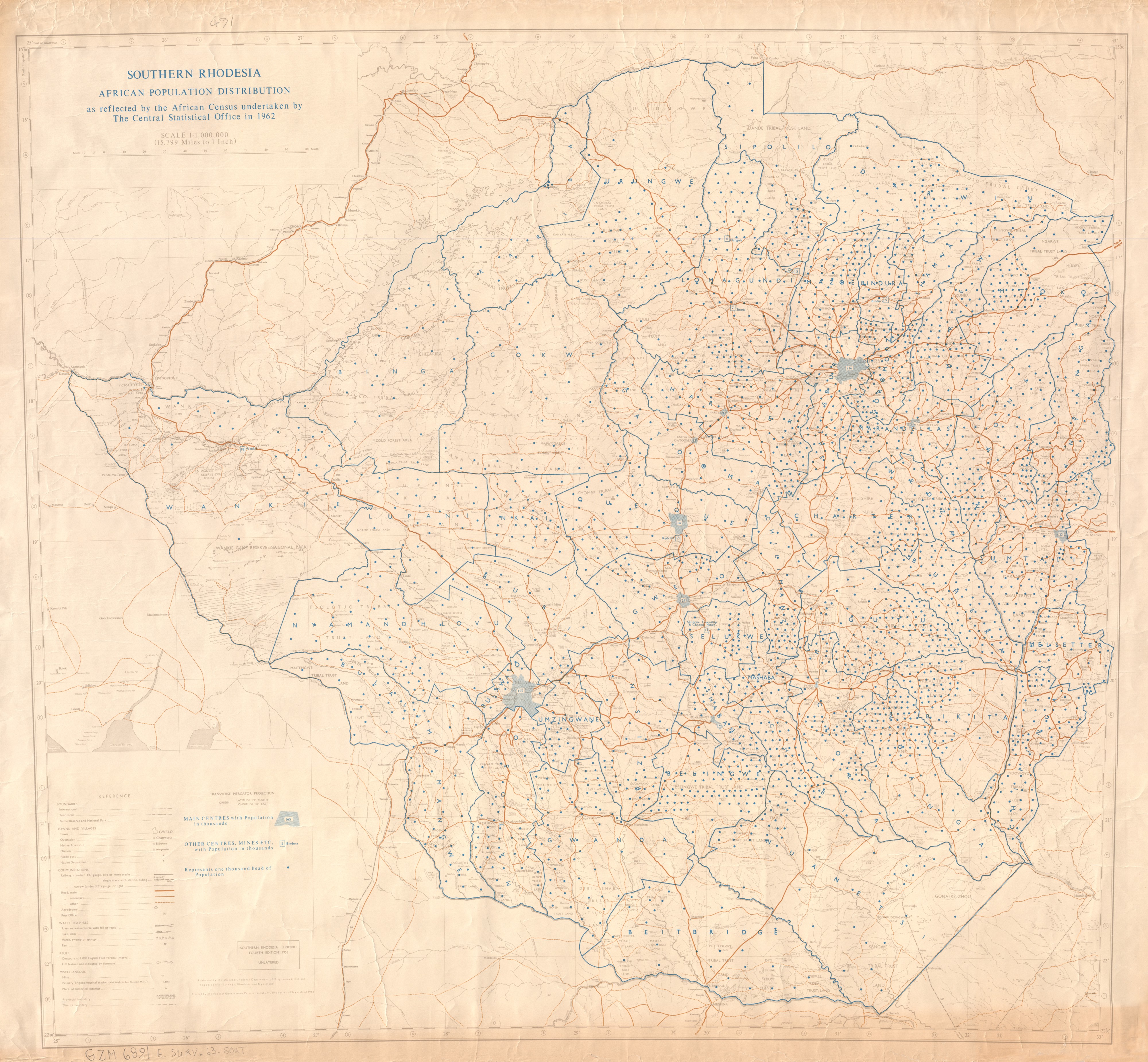 |
Details Title: Southern Rhodesia African population distribution as reflected by the African Census undertaken by the Central Statistical Office in 1962 Creator: Rhodesia and Nyasaland. Federal Department of Trigonometrical and Topographical Surveys. Subject Blacks--Zimbabwe--Population--Maps, Demography--Zimbabwe--Maps Description: Map of Southern Rhodesia showing the distribution of the African population according to main centres, and other centres and mines, with international, territorial, provincial and district boundaries, game reserves and national parks, towns, outstations, native townships, missions, police posts, native department posts, railways, roads, aerodromes, post offices, rivers, lakes, dams, marshes, swamps, sponges, pans, contours, mines, primary trigonometric stations, places of historical interest. Note: Some colour. Date: Fourth edition. 1956. Scale 1 : 1,000,000. Format: 79 x 84 cm. on sheet 84 x 92 cm. Coverage: Zimbabwe, E 25°00'--E 33°00'/S 15°30'--S 22°30' Format: JPG Size: 3.7 mb |
 |
Details Title: Southern Rhodesia. Salisbury District Creator Southern Rhodesia. Survey Unit (Reserve Section). Description Map of the Salisbury District of Southern Rhodesia, with Salisbury town and suburbs, farms, farm boundaries fenced, paddock fences, gates, railways, roads, tracks and footpaths, trigonometrical stations, buildings, British South Africa Police Stations, missions, bridges, ruins, mines, mine dumps, quarries, compounds or kraals, plantations, rivers or watercourses, vleis, dams, aerodromes, landing grounds, wireless stations. Misc: Some colour. Relief shown by contours and form lines. Scale: 1 : 100,000. Contributor: Southern Rhodesia. Government Lithographic Press. (contributor) Date: 1942. Size: 42 x 66 cm. on sheet 69 x 77 cm. Relation: Southern Rhodesia topographical series, military edition. Coverage: Salisbury, E 30°45'--E 31°15'/S 18°00--S 17°40' Format: JPG Size: 3.8 mb |
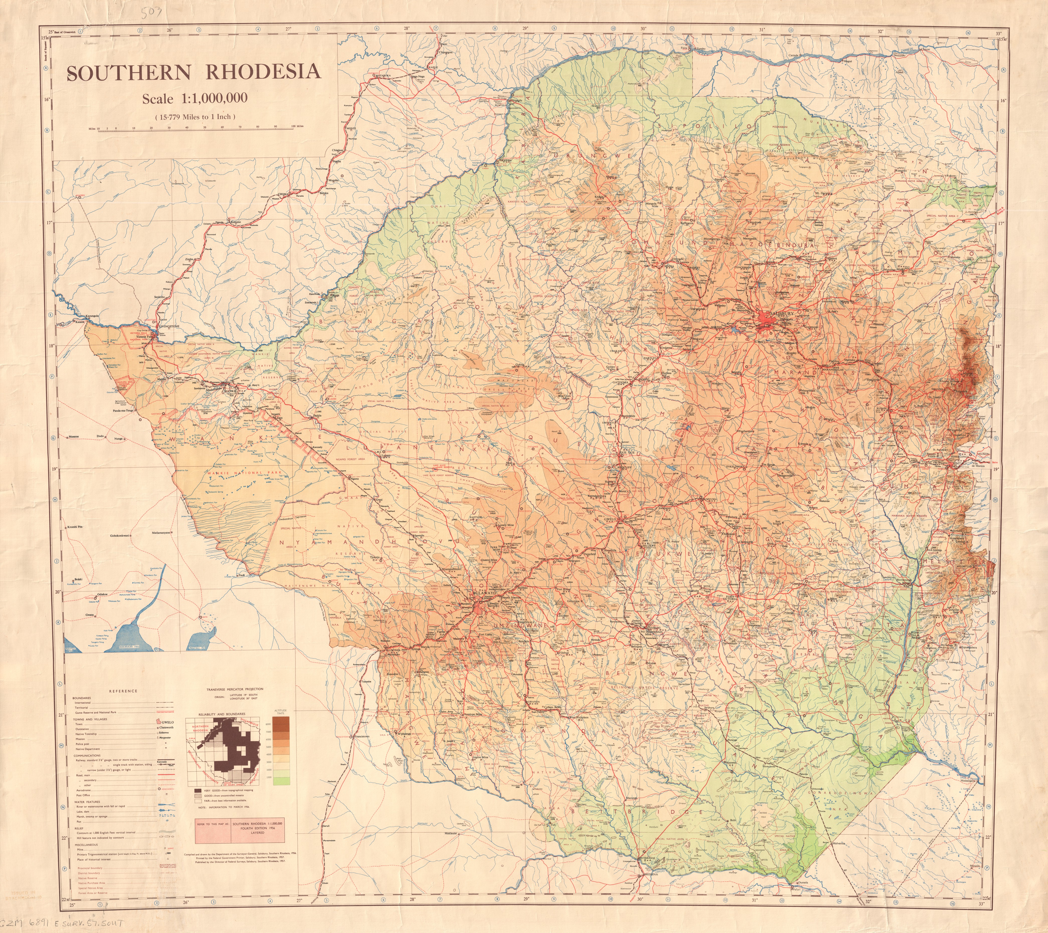 |
Details Title: Southern Rhodesia Creator: Southern Rhodesia. Department of the Surveyor-General. Description Map of Southern Rhodesia showing international, territorial, provincial, district, native reserve, native purchase area, special native area, forest area or reserve, game reserve and national park boundaries, towns, outstations, native townships, missions, police posts, native department posts, railways, roads, aerodromes, post offices, rivers, watercourses, lakes, dams, marsh, pans, mines, trigonometrical stations, places of historical interest. Misc: Colour.Relief shown by form lines, hachures and altitude tints. Date: Fourth edition, 1956. Scale 1 : 1,000,000. Date Printed: 1957 Size: 79 x 86 cm. on sheet 85 x 96 cm. Coverage: Zimbabwe, E 25°00'--E 33°00'/S 15°30'--S 22°30' Format: JPG Size: 4.8 mb |
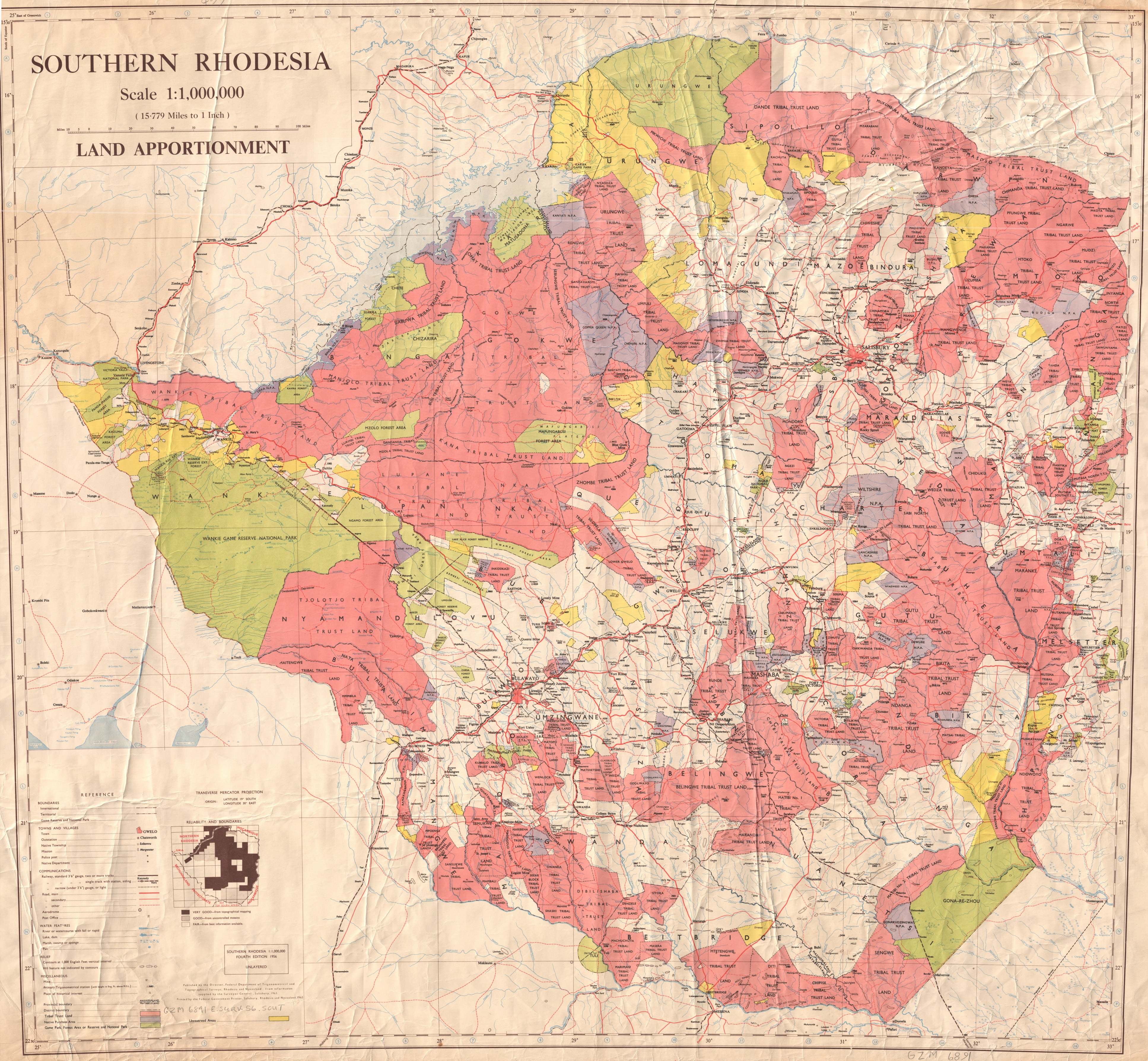 |
Details Title: Southern Rhodesia, Land Apportionment Creator: Rhodesia and Nyasaland. Federal Department of Trigonometrical and Topographical Surveys. Subject Land tenure--Zimbabwe--Maps, National parks and reserves--Zimbabwe--Maps Description: Map of Southern Rhodesia showing tribal trust lands, native purchase areas and game parks, forest areas or reserves and national parks, with international, territorial and district boundaries, towns, outstations, native townships, missions, police posts, native department posts, railways, roads, aerodromes, post offices, water features, rivers, lakes, dams, marshes, swamps, sponges, pans, mines, primary trigonometric stations, places of historic interest. Misc: Colour. Fourth edition. Relief is shown by spot heights. Scale 1 : 1,000,000. Date: 1956, 1963 printing. Size: 79 x 84 cm. on sheet 82 x 89 cm. Coverage Zimbabwe, E 25°00'--E 33°00'/S 15°30'--S 22°30' Format: JPG Size: 4.2 mb |
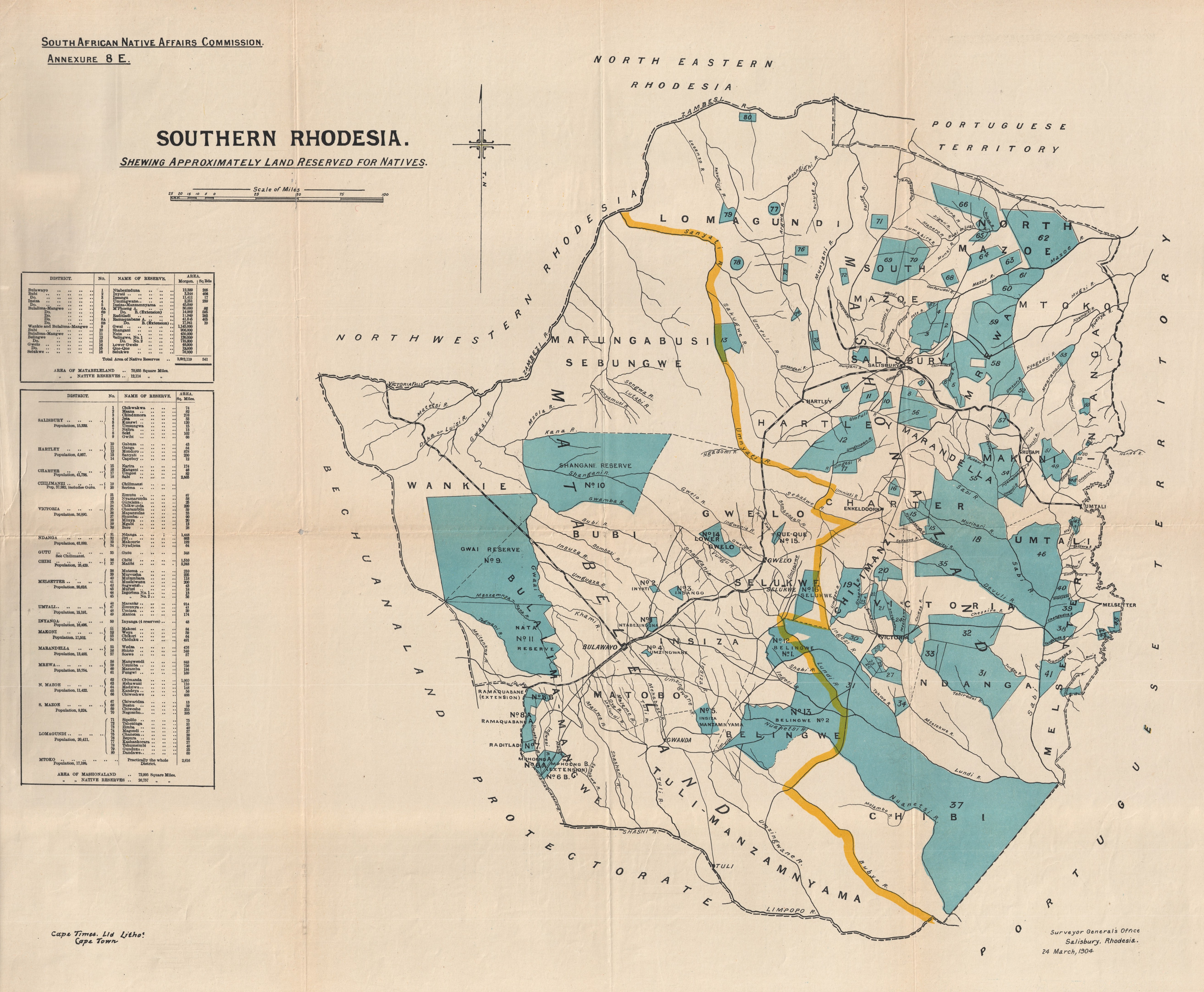 |
Details Title: Southern Rhodesia, Shewing Approximately Land Reserved For Natives Creator: Southern Rhodesia. Surveyor General's Office. Subject: Blacks--Land tenure--Zimbabwe--Maps Description: A map of Southern Rhodesia native reserves, with rivers, place names and railway lines. Some colour. Scale: 1 inch to 25 miles. Contributor: South African Native Affairs Commission. (contributor), Cape Times Ltd., lithographers. (contributor) Date: 1904 March 24 Size: 59 x 72 cm. Relation: Report of the South African Native Affairs Commission, 1903-1905. Annexure 8.E. Format: JPG Size: 4.4 mb |
 |
Details Creator: Ravenstein, Ernst Georg, 1834-1913 Printer: George Philip & Son, 32 Fleet St., London, England Published by the Royal Geographical Society. Publication: The Geographical Journal, v. 1, between pp. 384-385, 1893 Title: Part of South Africa showing the routes of FREDERICK COURTNEY SELOUS 1872-92 Scale: 1: 5.000.000 Dimensions: 20.5 x 31.7 cm. Format: JPG Size: 33.5 mb Notes: Relief shown by tinting. |
|
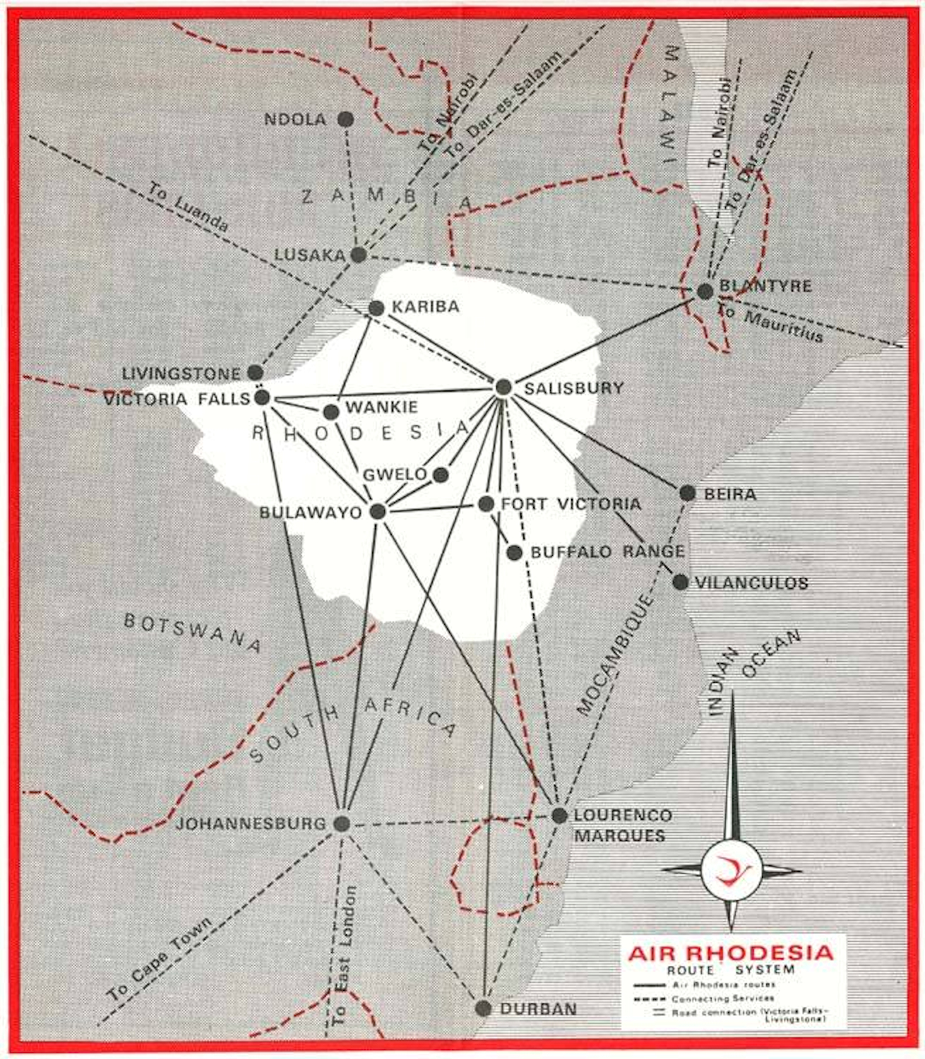
Details Title: Air Rhodesia Route System Format: JPG Size: 1.4 mb Note: Air Rhodesia was the national airline of Rhodesia. Its head office was located at Salisbury Airport in Salisbury. The airline was formed as a subsidiary of Central African Airways (CAA) in June 1964, but became an independent corporation on 1 September 1967. Air Rhodesia's primary aircraft were the Vickers Viscount 700D turboprops and Boeing 720 jetliners, three of which were successfully purchased in April 1973 despite sanctions against the Rhodesian government. In 1979 the airline became known as Air Zimbabwe Rhodesia, bthen as Air Zimbabwe in 1980. |

|
Details Creator: Southern Rhodesia. Department of Publicity Title: A pictorial map of Southern Rhodesia / designed and reproduced at the Government Lithographic Press for the Dept. of Publicity. Salsibury, S. Rhodesia, 1938 ; A.W. Baylis, 1937 Created/Published: [Salisbury, S. Rhodesia] : [Government Lithographic Press], 1938 Extent: 1 map : colour ; 91 x 59 cm, on sheet 95 x 62 cm Format: JPG Size: 43 mb |

|
Details Creator: Great Britain. Central Office of Information Title: Southern Rhodesia / prepared by the Central Office of Information Created/Published: [London] : H.M. Stationery Office, [19--?] Extent: 1 map : col. ; 34 x 67 cm. Format: JPG Size: 125 mb |
|
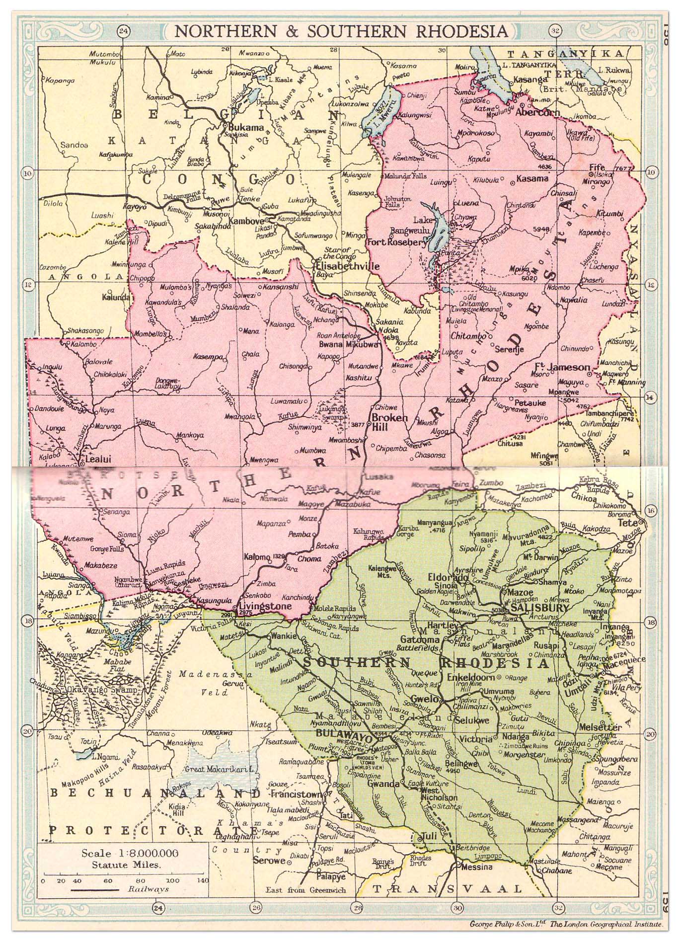
Details Creator: George Philip & Son Ltd., The London Geograpical Institute Title: Northern & Southern Rhodesia. Year: 1935 Format: JPG Size: 500 kb |

|
Details Creator: United States. Central Intelligence Agency Title: Southern Rhodesia (U.K.) / [Central Intelligence Agency] Created/Published: [Washington, D.C.] : [Central Intelligence Agency], [1970] Extent: 1 map : colour ; 39 x 43 cm., on sheet 55 x 70 cm Format: JPG Size: 29 mb |

|
Details Imprint: Rhodesia: Reprinted by Books of Rhodesia Publishing Co. (Pvt.) Ltd. P.O. Box 1994, Bulawayo, 1994 Language: French Extent: 1 map : color ; 47 x 60 cm on sheet 57 x 66 cm Scale: Not determined ; E 5°33'00"--E 55°44'00"/N 2°00'00"--S 35°30'00" Format: JPG Size: 29.5 mb Notes: Reprint of Carte du Congo et du Pays des Cafres by Guillaume de l'Isle de l'Academie Royale des Sciences (Amsterdam : Chez Jean Covens et Corneille Mortier, Geographes, 1742). Coordinates approximate and based on Greenwich meridian. Scale statement: Lieues Marines ou Lieues d'un heure de chemin. |
|
Details Title: Cape Government Railways map : Showing routes of railways in South Africa Imprint: Cape Town : Townshend, Taylor and Snashall. Lithographers, 1908 Extent: 1 map : color ; 69 x 55 cm Map data: Scale not determined ; E 9°00'00"--E 42°37'00"/S 0°55'00"--S 37°38'00" Format: JPG Size: 26 mb Note: The map shows the railway routes in the Cape Colony, Orange Free State, Transvaal, Natal, Zululand, Griqualand East and Pondoland in present-day South Africa as well as in Rhodesia. Indicates the neighbouring British Bechaunaland Protectorate, German South West Africa, Basuto Land, and Portuguese Territory but no railway routes are shown in these territories. Coordinates approximate and based on Greenwich meridian. Bar scale on map given in "Miles." Includes rivers, lakes, the Atlantic Ocean to the west and the Indian Ocean to the east. The reference key points to the "Cape Government Railways & Lines administered by the Cape Government", "Other Railways", and [railways] "under construction authorised or proposed". An inset map in the bottom right corner shows Cape Town and surroundings as well as detailed railway routes as far as Kalabas Kraal, Malan, French Hoek [Franschhoek] and Caledon. A small section of the top left side of the map has been torn off but no image or text is affected. The map is torn along the left hand folds. |
|
Details Standard railway map of South Africa Imprint: Pretoria : Photo-lithographed at the Government Printing Works, 1920 Extent: 1 map ; 98 x 72 cm Scale: 1:3,500,000 ; E 11°40'00"--E 38°20'00"/S 6°20'00"--S 36°10'00" Format: JPG Size: 16 mb Note: The map shows railways in the Cape of Good Hope, South West Africa, British protectorate of Bechuanaland, Basutoland, Portuguese East Africa, Nyasaland, Belgian Congo, as well as north west, southern and north east Rhodesia. The reference list shows the lines controlled by South African Railways, Rhodesia Railways, Beira and Mashonaland Railways, Caminho de Ferro de Lourenço Marques, Portuguese East Africa, Belgian Congo, private railways, lines projected or under construction, road motor services, sidings and grain elevator stations. Indicates towns, bays, rivers, lakes, pans and marshes. It also shows the Atlantic Ocean and Indian Ocean as well as distances between ports along the coast of Southern Africa from Walvis Bay to Beira. Scale 1:3,500,000. Bar scale on map given in "Miles." "Compiled on the basis of Bonne's projection (Central meridian 25° East Longitude)." "Drawn in the office of the Chief Civil Engineer, S.A.R., Johannesburg." Legend beneath title. Translations in Afrikaans. With 5 inset maps: Port Elizabeth and environs -- Cape Town and environs -- Johannesburg - Pretoria and environs -- Durban - Pietermaritzburg and environs -- and East London and environs. |
|
Details Federal atlas map: [Federation of Rhodesia and Nyasaland], Map 1. Title: Africa. Scale: 1:15,000,000. Date: 1962. Format: JPG Size: 16 mb |
|
Details Federal atlas map: [Federation of Rhodesia and Nyasaland], Map 2. Title: Southern Africa: communications. 1:6,000,000. 1961. Scale: 1:6,000,000. Date: 1961. Format: JPG Size: 16 mb |
|
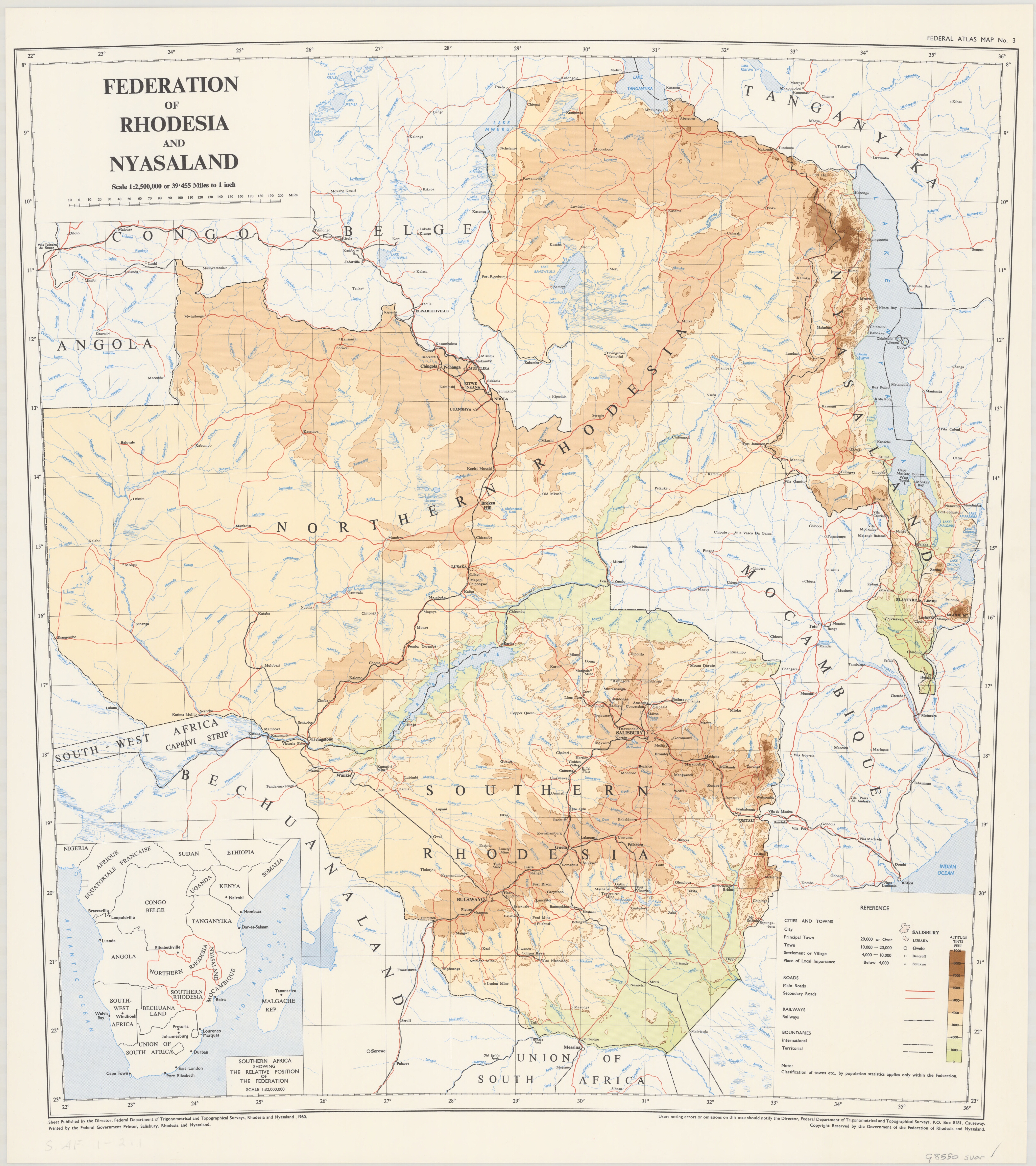
Details Federal atlas map: [Federation of Rhodesia and Nyasaland], Map 3. Title: Federation of Rhodesia and Nyasaland. Scale: 1:2,500,000. Date: 1960. Format: JPG Size: 16 mb |
|
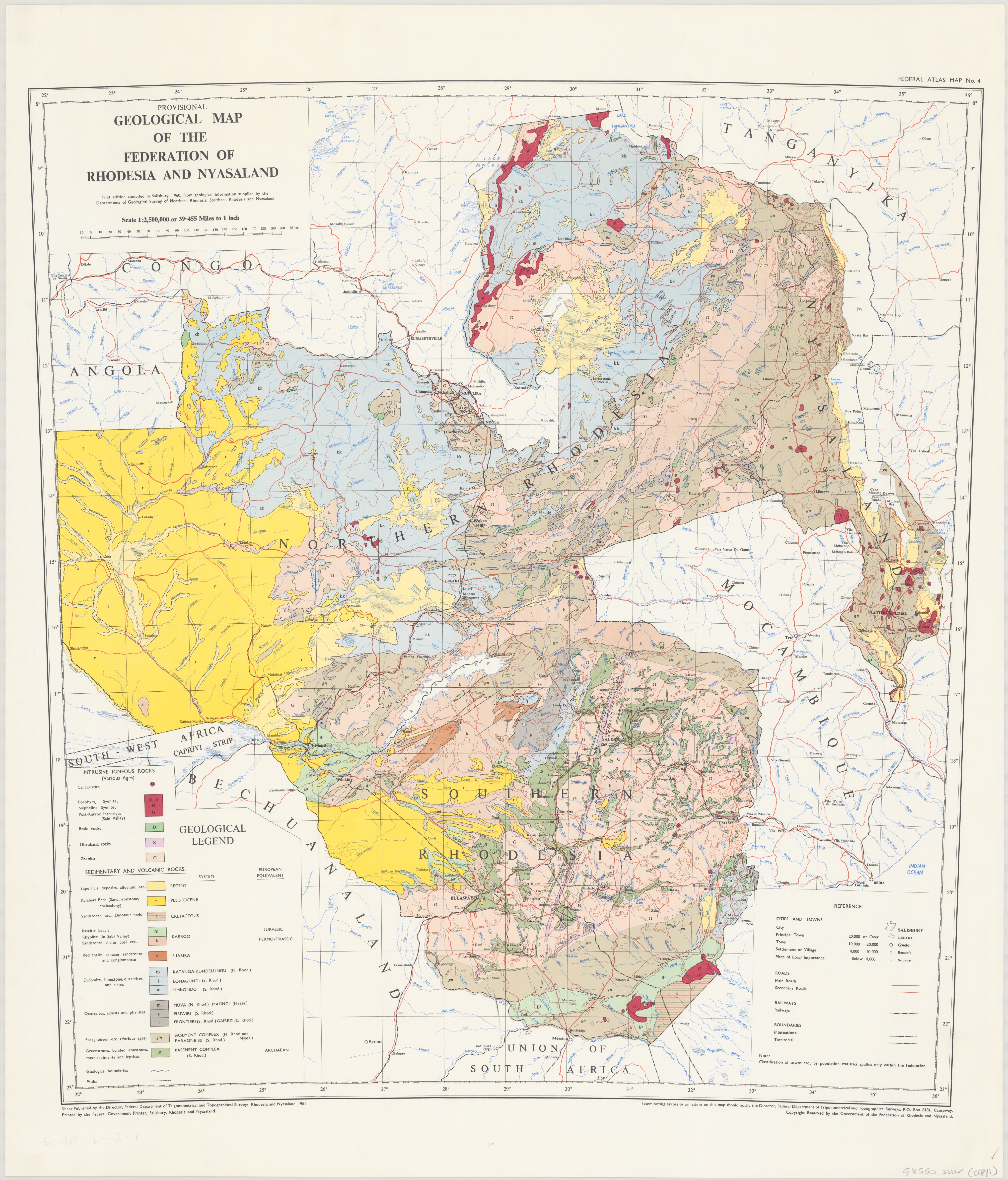
Details Federal atlas map: [Federation of Rhodesia and Nyasaland], Map 4. Title: Provisional geological map of the Federation of Rhodesia and Nyasaland. Scale: 1:2,500,000. Date: 1961 Format: JPG Size: 16 mb |
|
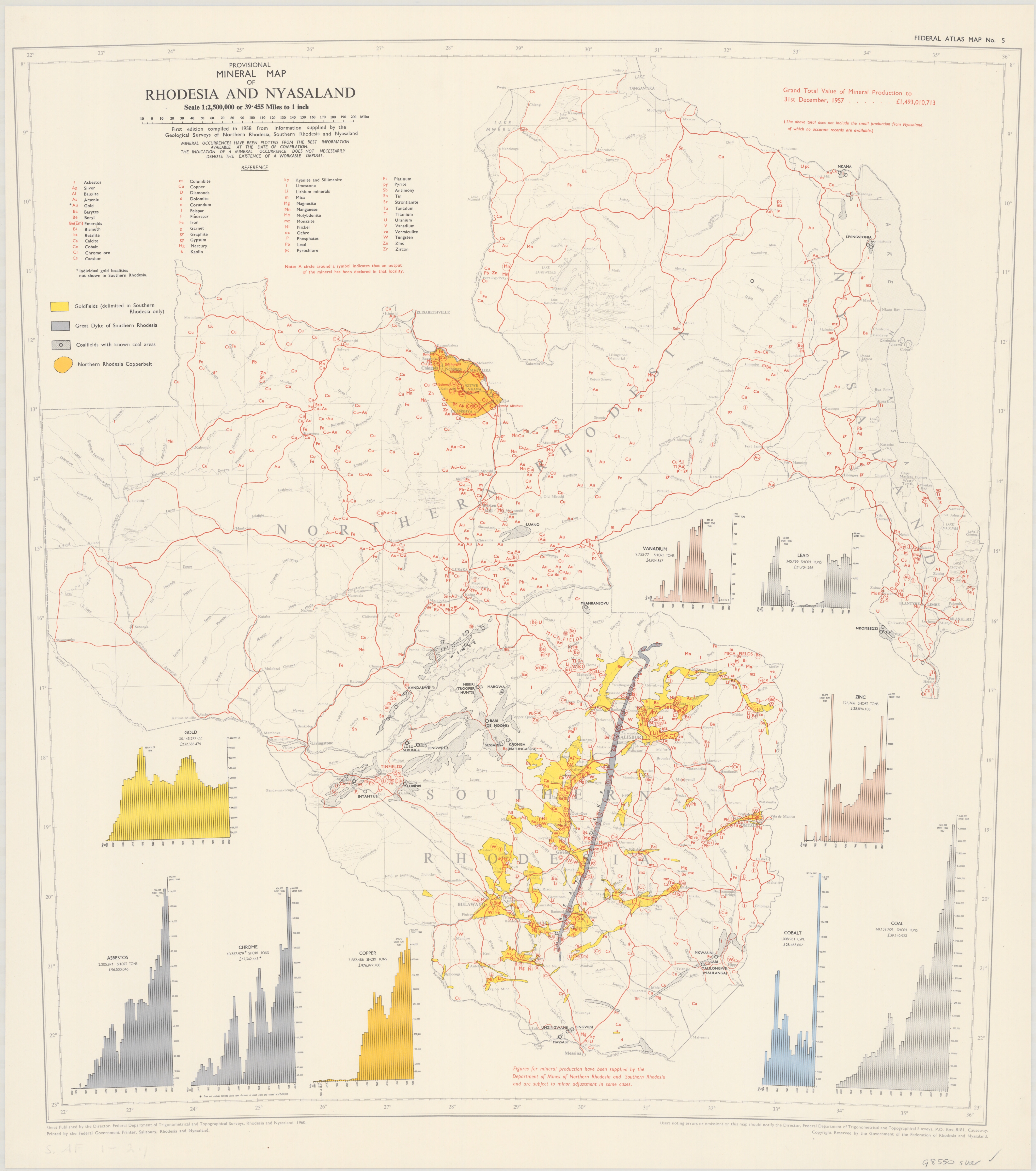
Details Federal atlas map: [Federation of Rhodesia and Nyasaland], Map 5. Title: Provisional mineral map of Rhodesia and Nyasaland. Scale: 1:2,500,000. Date: 1960. Format: JPG Size: 13.5 mb |
|
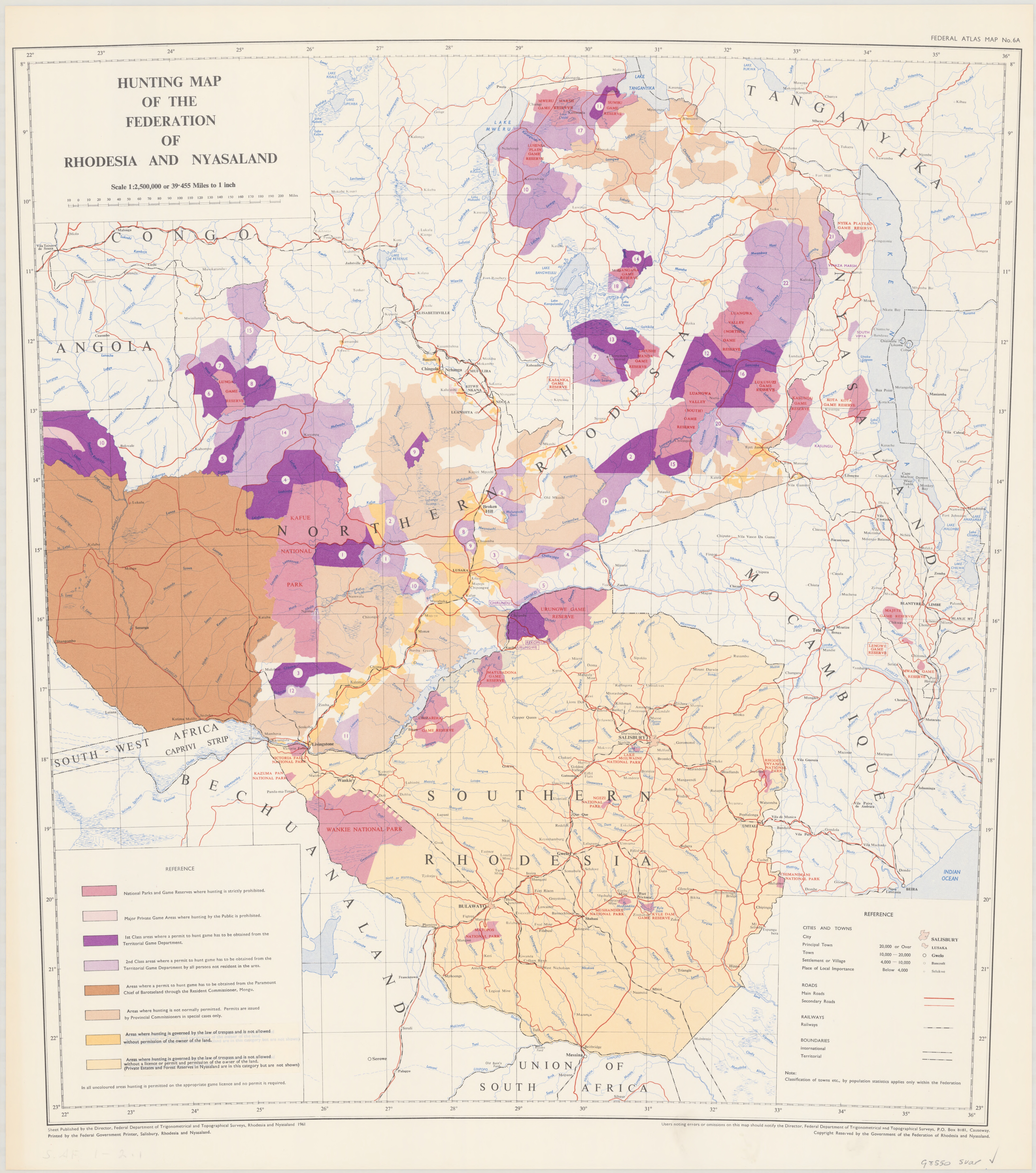
Details Federal atlas map: [Federation of Rhodesia and Nyasaland], Map 6A. Title: Hunting map of the Federation of Rhodesia and Nyasaland. Scale: 1:2,500,000. Date: 1961. Format: JPG Size: 16 mb |
|
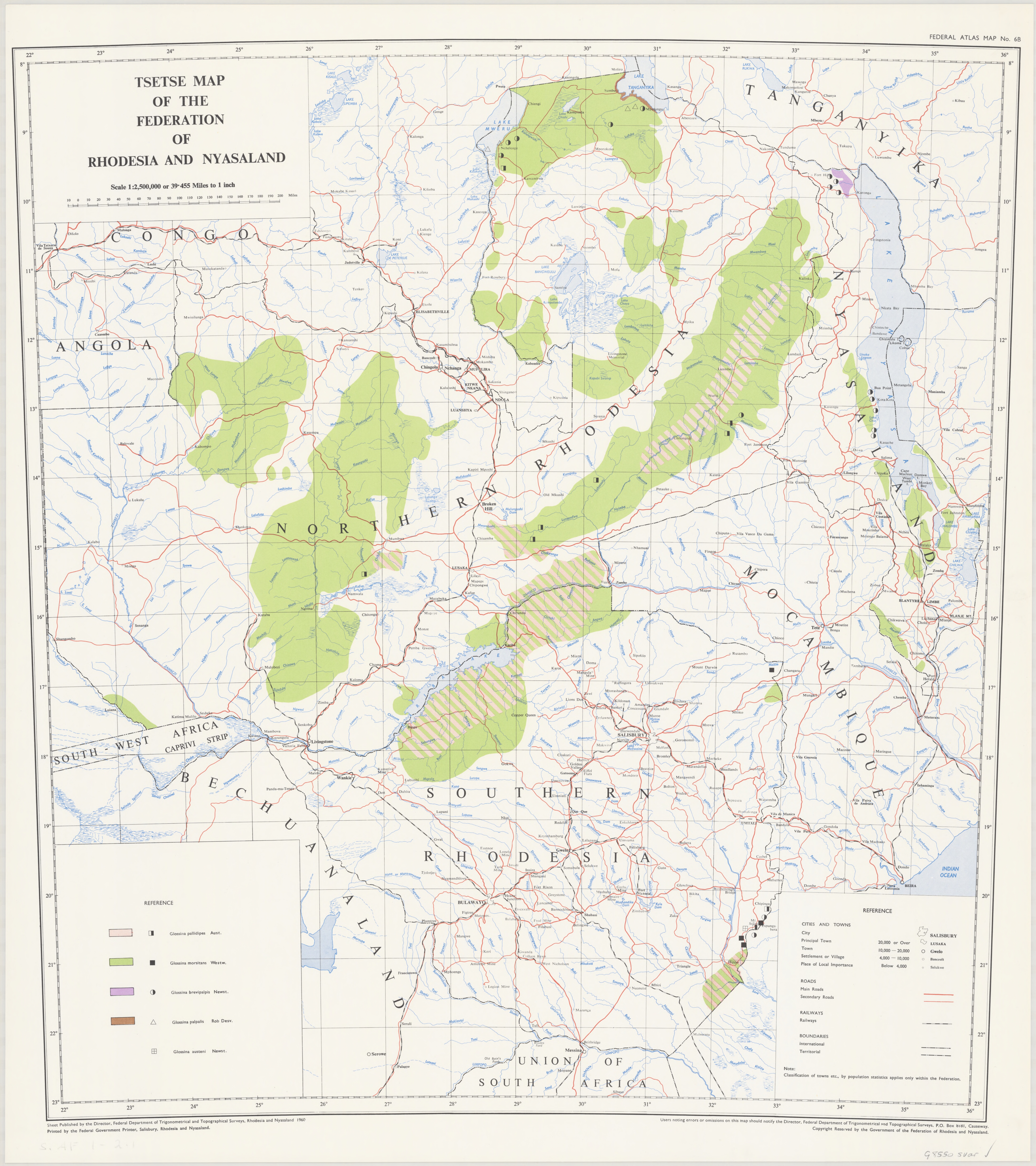
Details Federal atlas map: [Federation of Rhodesia and Nyasaland], Map 6B. Title: Tsetse map of the Federation of Rhodesia and Nyasaland. Scale: 1:2,500,000. Date: 1960. Format: JPG Size: 14 mb |
|
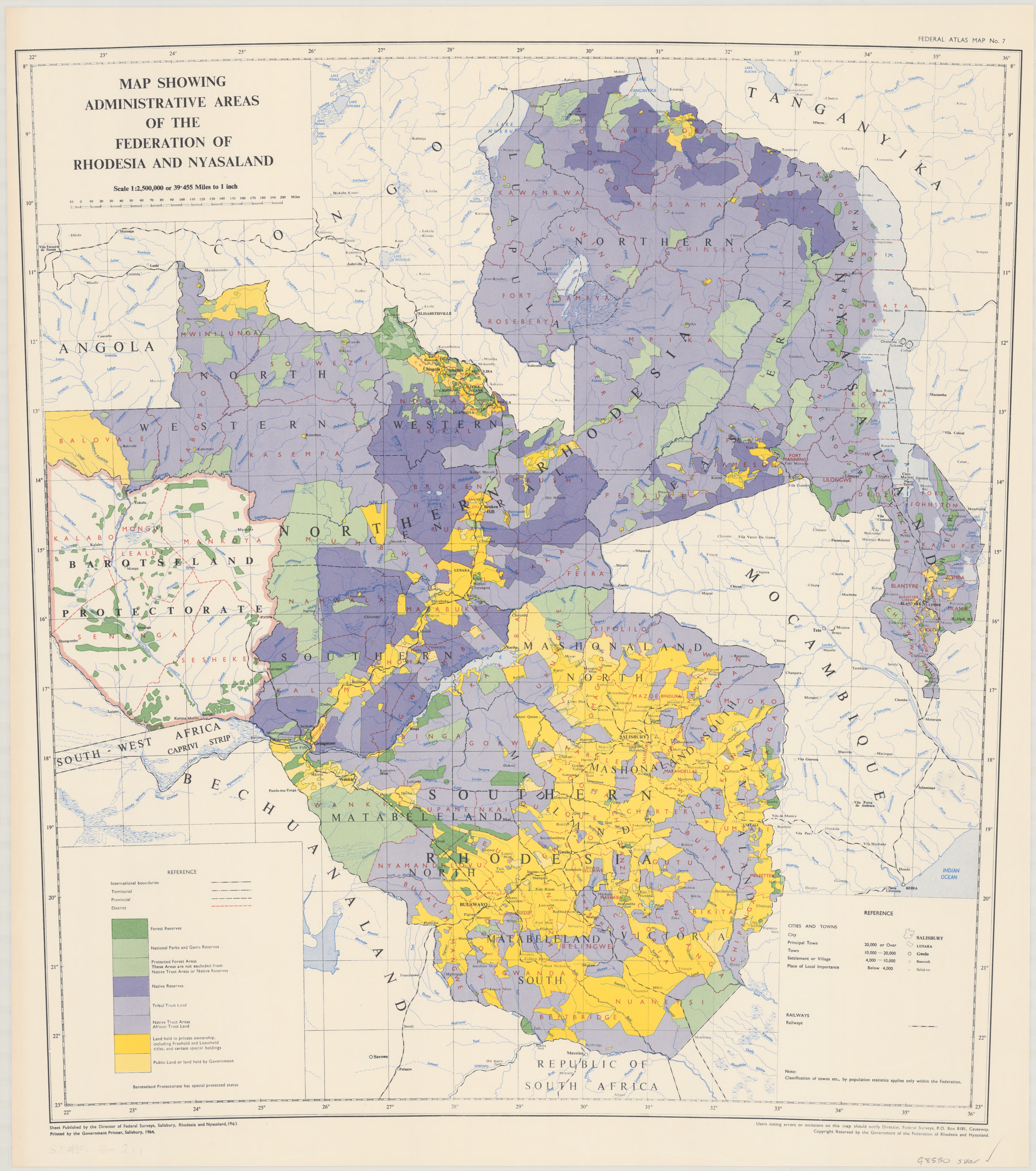
Details Federal atlas map: [Federation of Rhodesia and Nyasaland], Map 7. Title: Map showing the administrative areas of the Federation of Rhodesia and Nyasaland. Scale: 1:2,500,000. Date: 1963. Format: JPG Size: 17 mb |
|
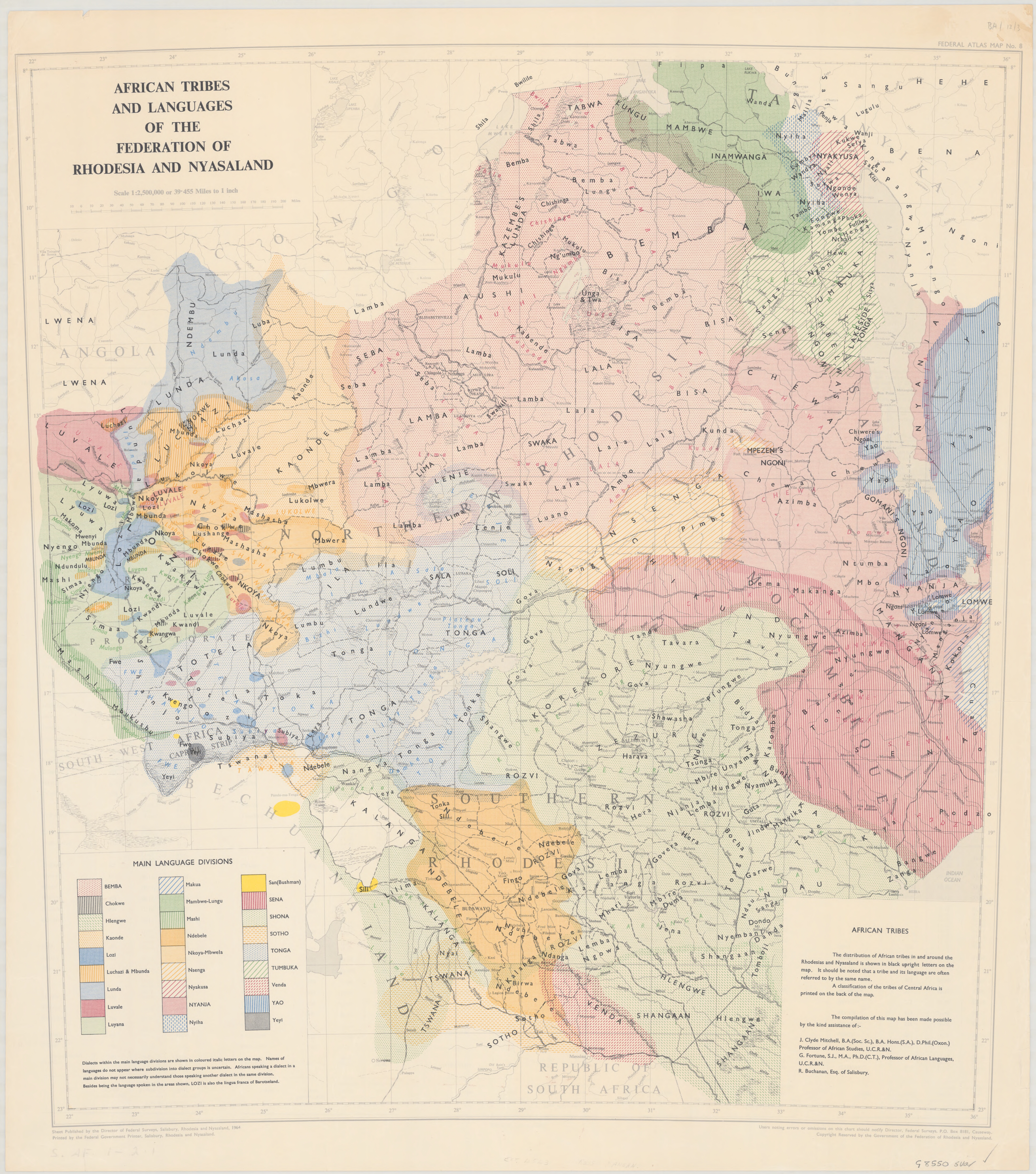
Details Federal atlas map: [Federation of Rhodesia and Nyasaland], Map 8. Title: African tribes and languages of the Federation of Rhodesia and Nyasaland. Scale: 1:2,500,000. Date: 1964. Format: JPG Size: 18.5 mb |
|
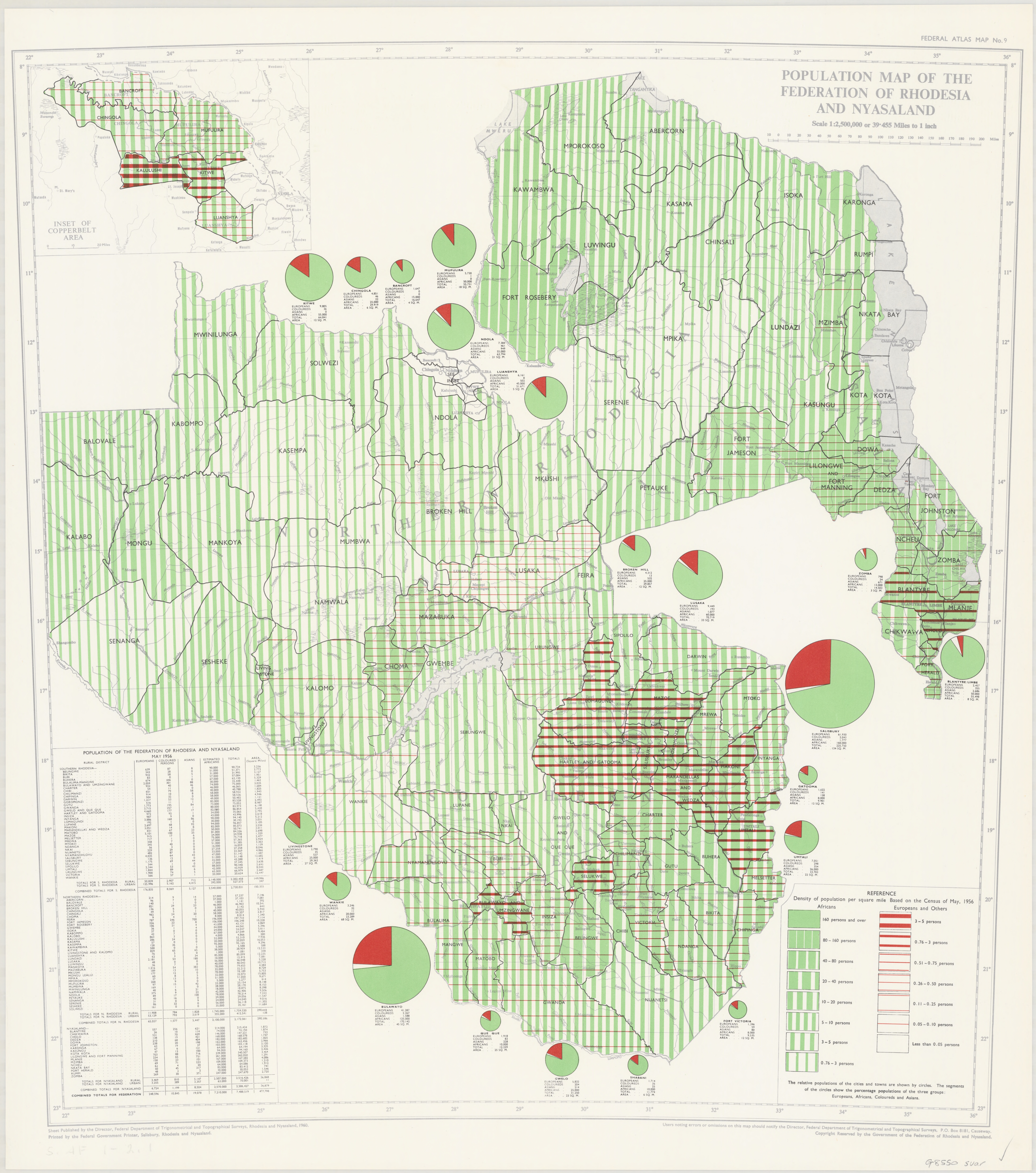
Details Federal atlas map: [Federation of Rhodesia and Nyasaland], Map 9. Title: Population map of the Federation of Rhodesia and Nyasaland. Scale: 1:2,500,000. Date: 1960. Format: JPG Size: 14 mb |
|
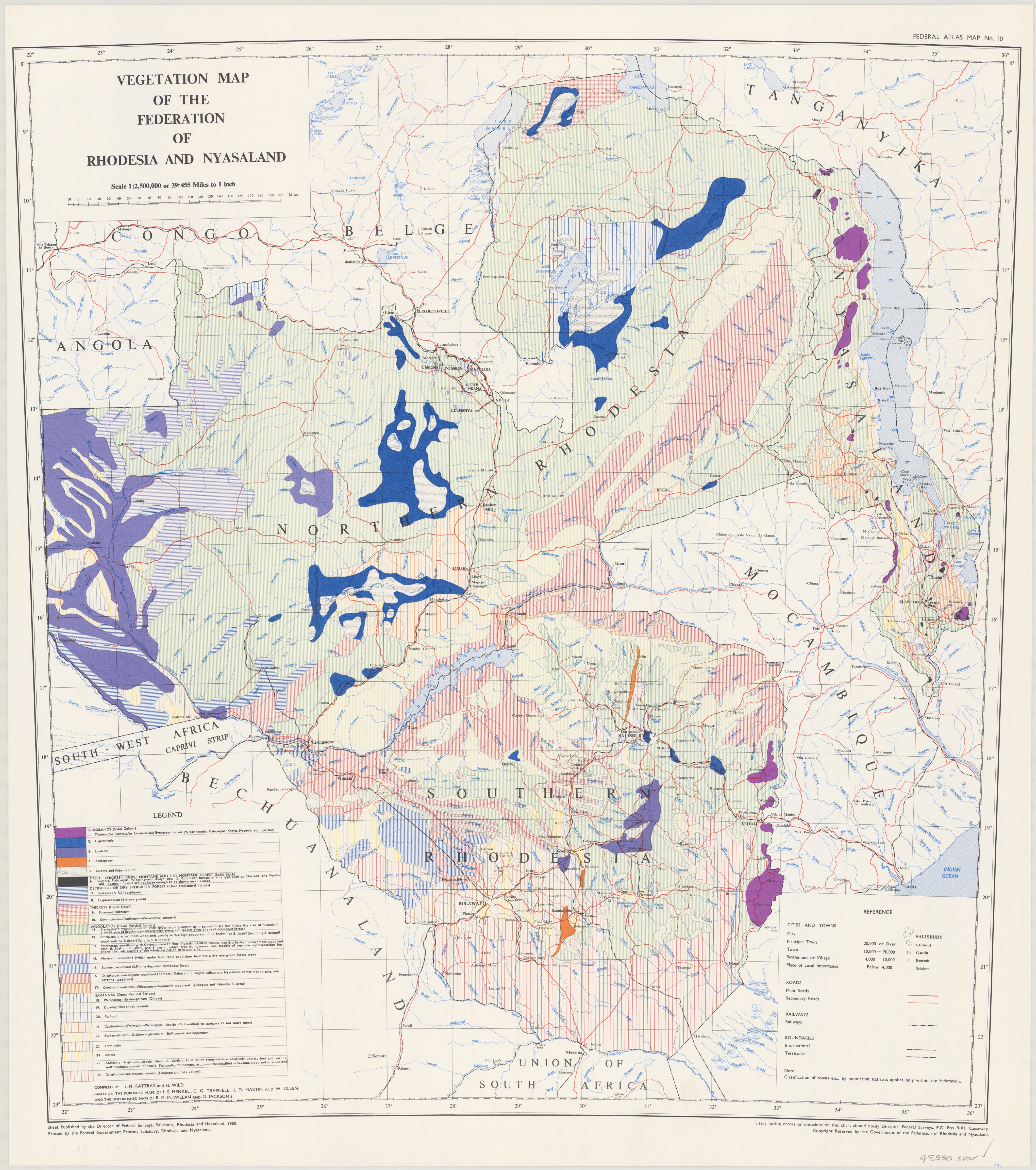
Details Federal atlas map: [Federation of Rhodesia and Nyasaland], Map 10. Title: Vegetation map of the Federation of Rhodesia and Nyasaland. Scale: 1:2,500,000. Date: 1960. Format: JPG Size: 16 mb |
|
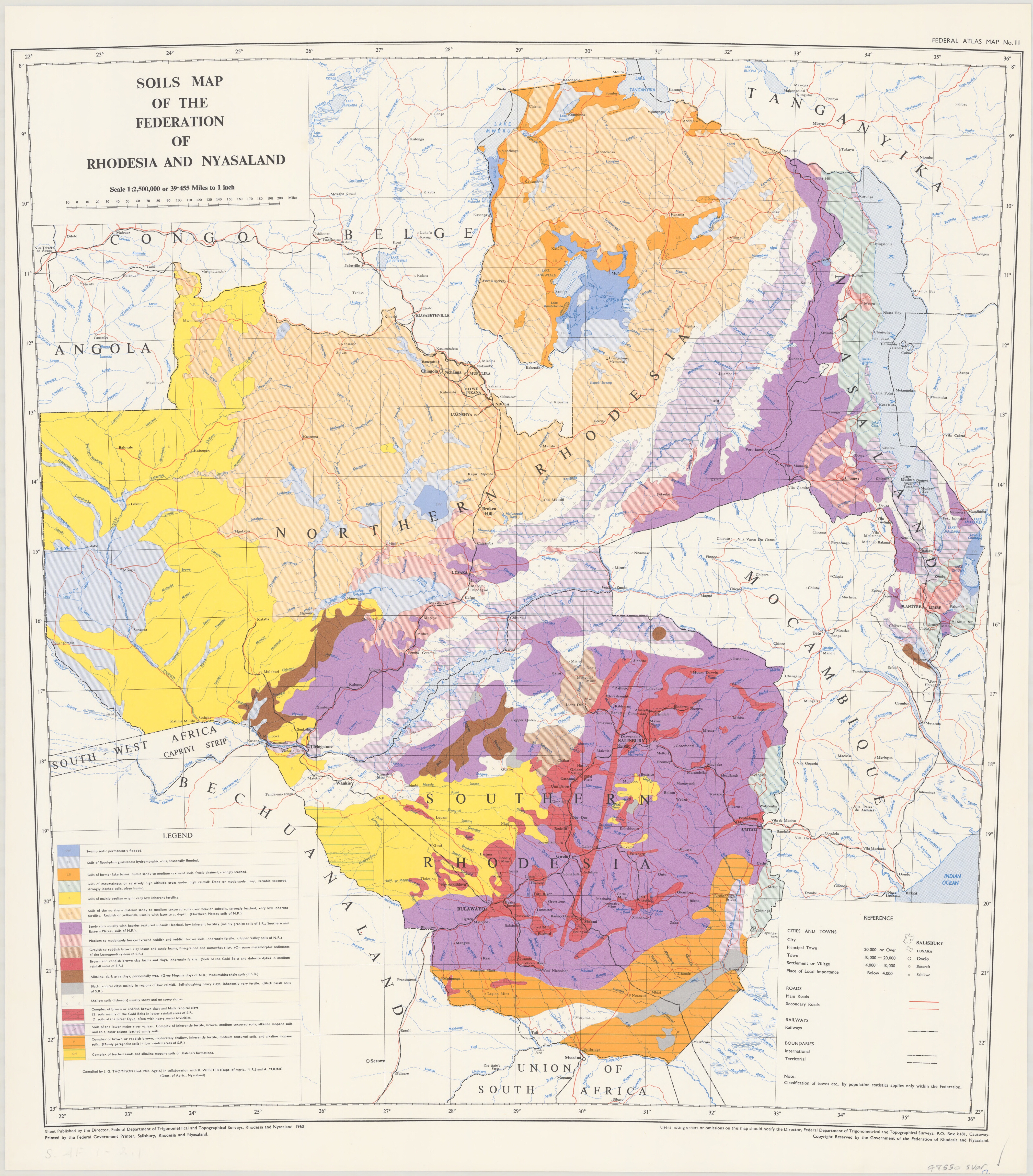
Details Federal atlas map: [Federation of Rhodesia and Nyasaland], Map 11. Title: Soils map of the Federation of Rhodesia and Nyasaland. Scale: 1:2,500,000. Date: 1960. Format: JPG Size: 16 mb |
![Rainfall map: Mean annual rainfall; Annual total rainfall likely to be reached or exceeded 1 year in 5; Annual rainfall likely to be reached or exceeded 4 years in 5; Variability of rainfall. All 1:5,000,000. [196-].](maps/nla.obj-234038443-12A.jpg)
|
Details Federal atlas map: [Federation of Rhodesia and Nyasaland], Map 12A. Title: Rainfall map: Mean annual rainfall; Annual total rainfall likely to be reached or exceeded 1 year in 5; Annual rainfall likely to be reached or exceeded 4 years in 5; Variability of rainfall. Scale: All 1:5,000,000. Date: [196-]. Format: JPG Size: 16 mb |
|
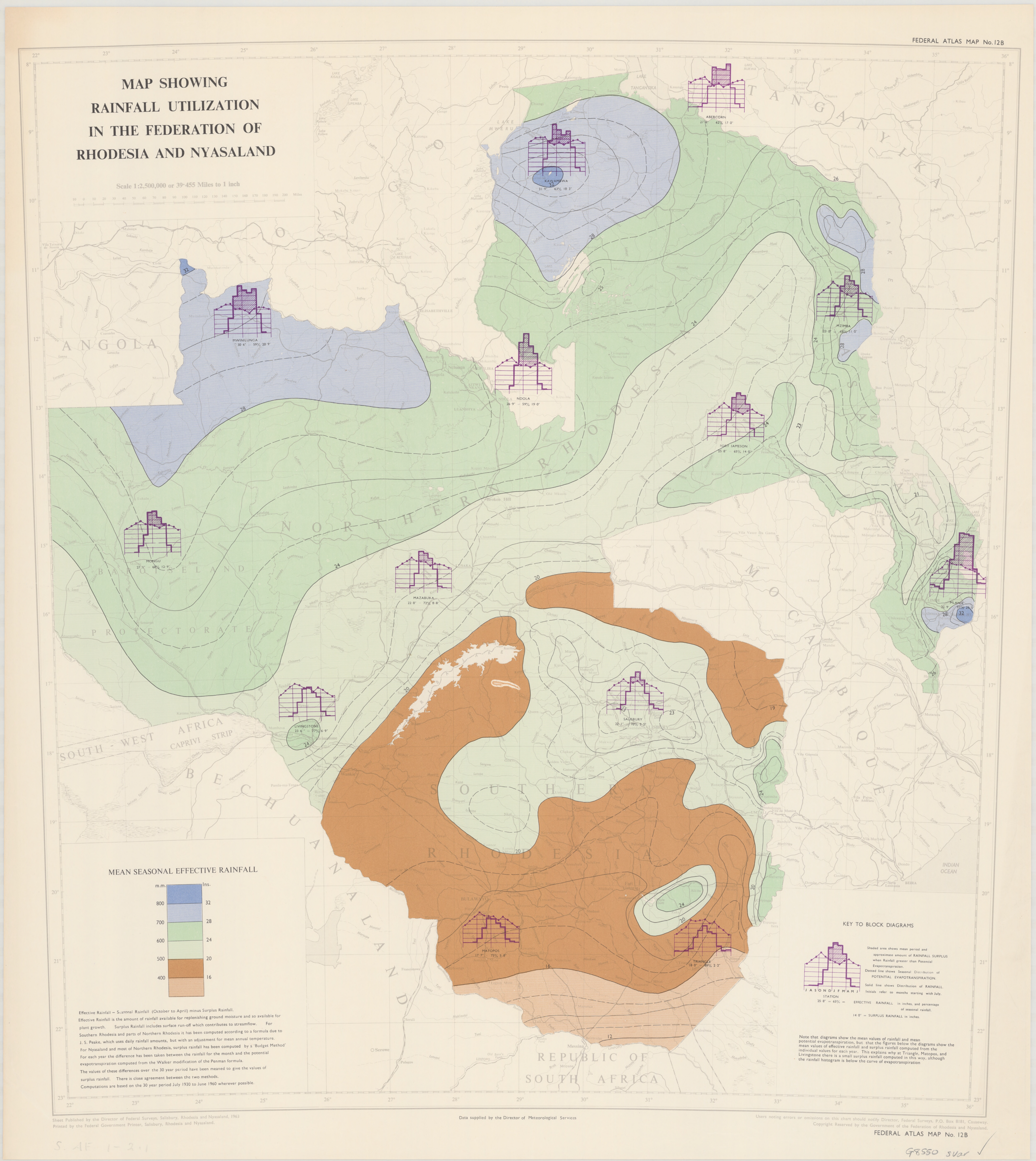
Details Federal atlas map: [Federation of Rhodesia and Nyasaland], Map 12B. Title: Map showing rainfall utilization in the Federation of Rhodesia and Nyasaland. Scale: 1:2,500,000. Date: 1963. Format: JPG Size: 13.5 mb |
|
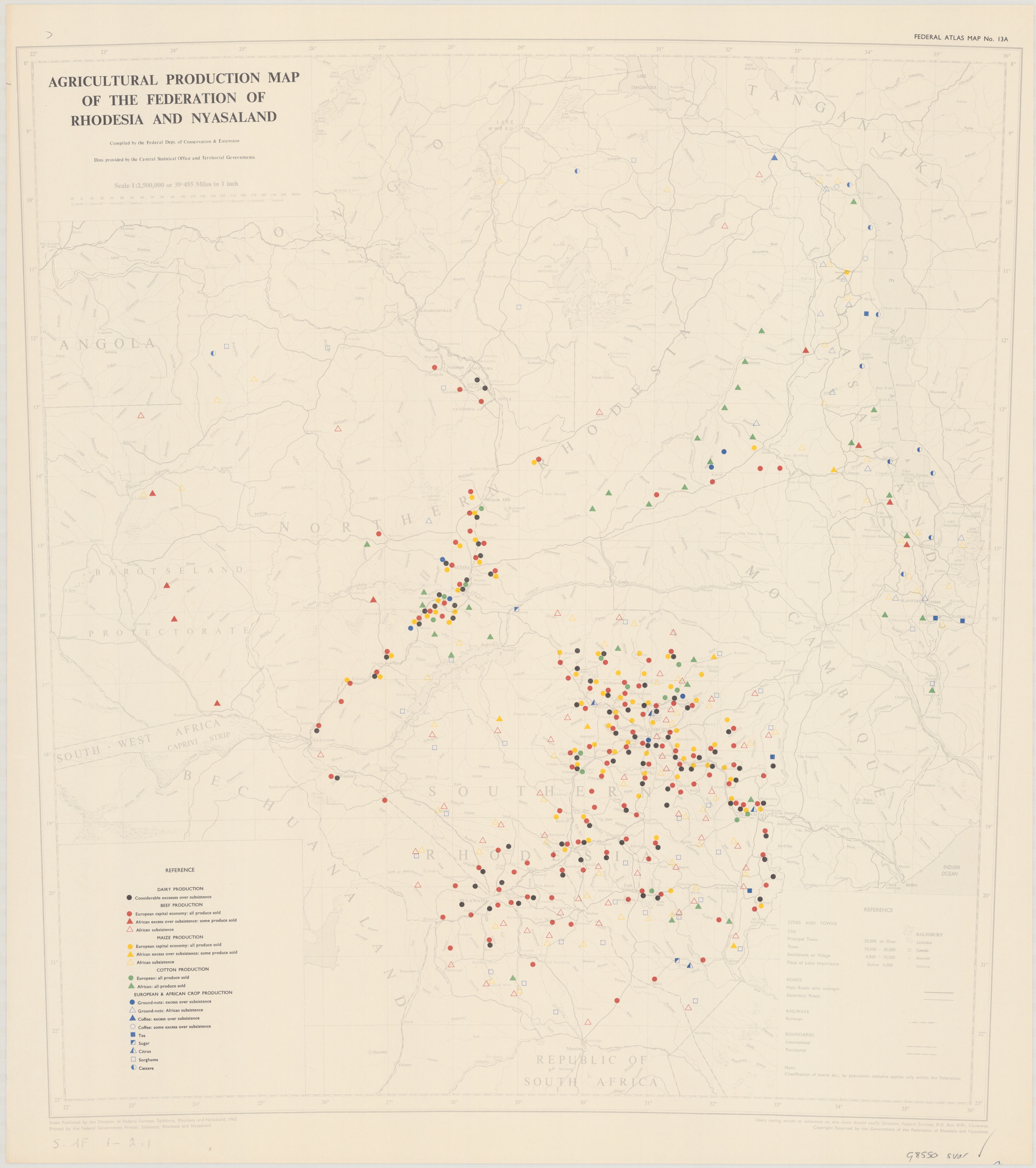
Details Federal atlas map: [Federation of Rhodesia and Nyasaland], Map 13A. Title: Agricultural production map of the Federation of Rhodesia and Nyasaland. Scale: 1:2,500,000. Date: 1962. Format: JPG Size: 14.5 mb |
|
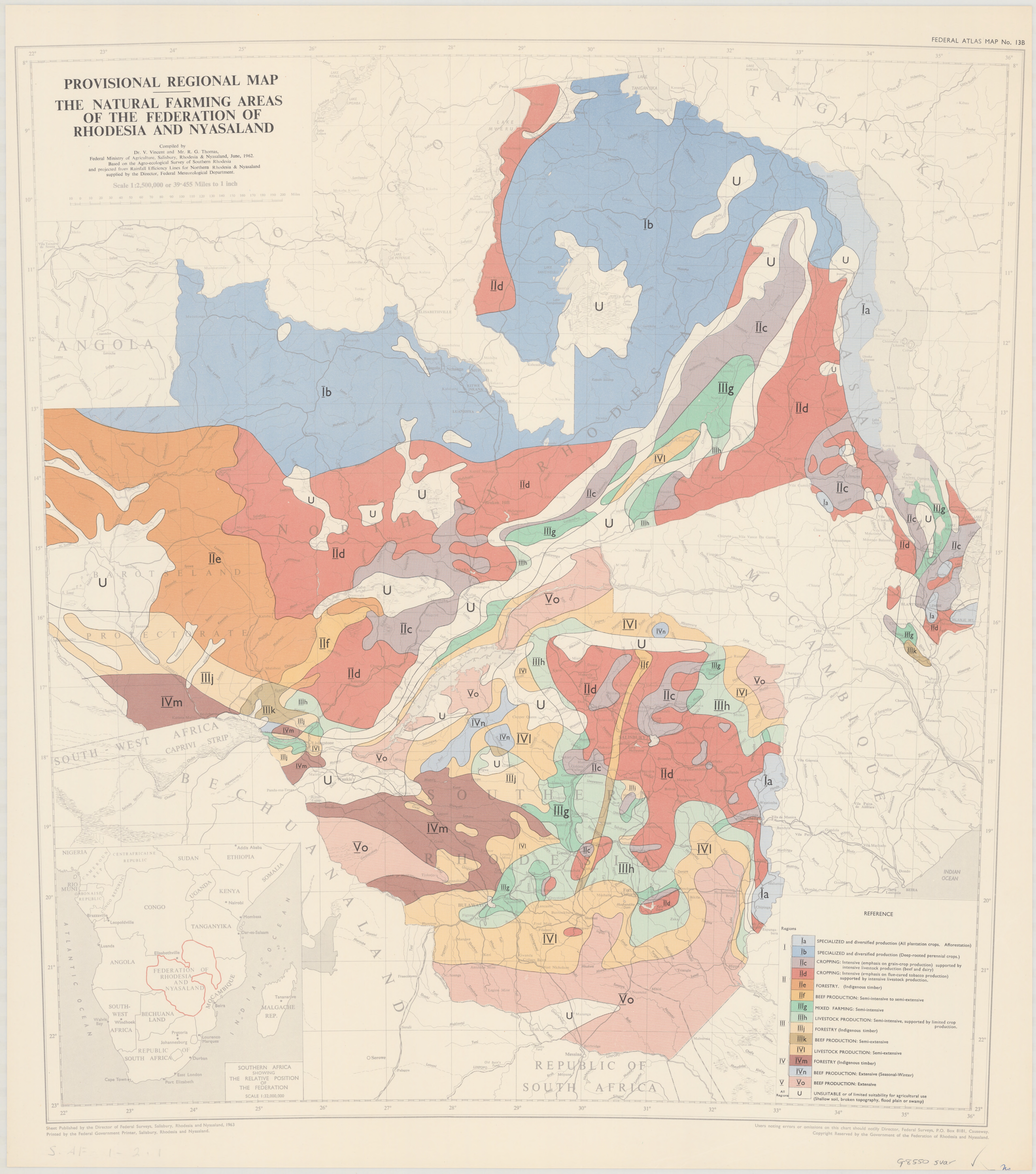
Details Federal atlas map: [Federation of Rhodesia and Nyasaland], Map 13B. Title: Provisional regional map: The natural farming areas of the Federation of Rhodesia and Nyasaland. Scale: 1:2,500,000. Date: 1963. Format: JPG Size: 14.5 mb |
|
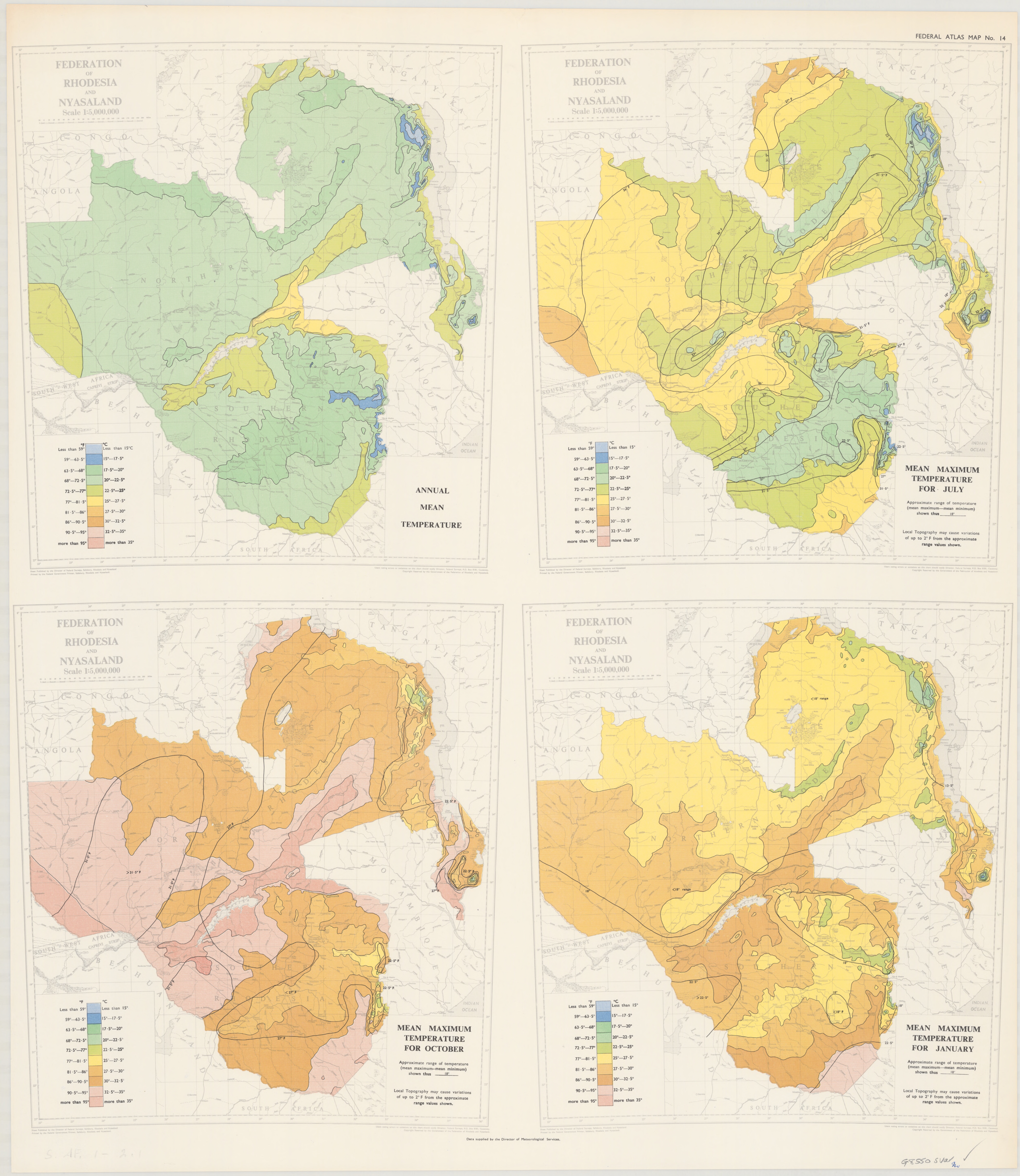
Details Federal atlas map: [Federation of Rhodesia and Nyasaland], Map 14. Title: Annual mean temperature; Mean maximum temperature for July; Mean maximum temperature for October; Mean maximum temperature for January. Scale: All 1:5,000,000. Date: 196-. Format: JPG Size: 15 mb |
|
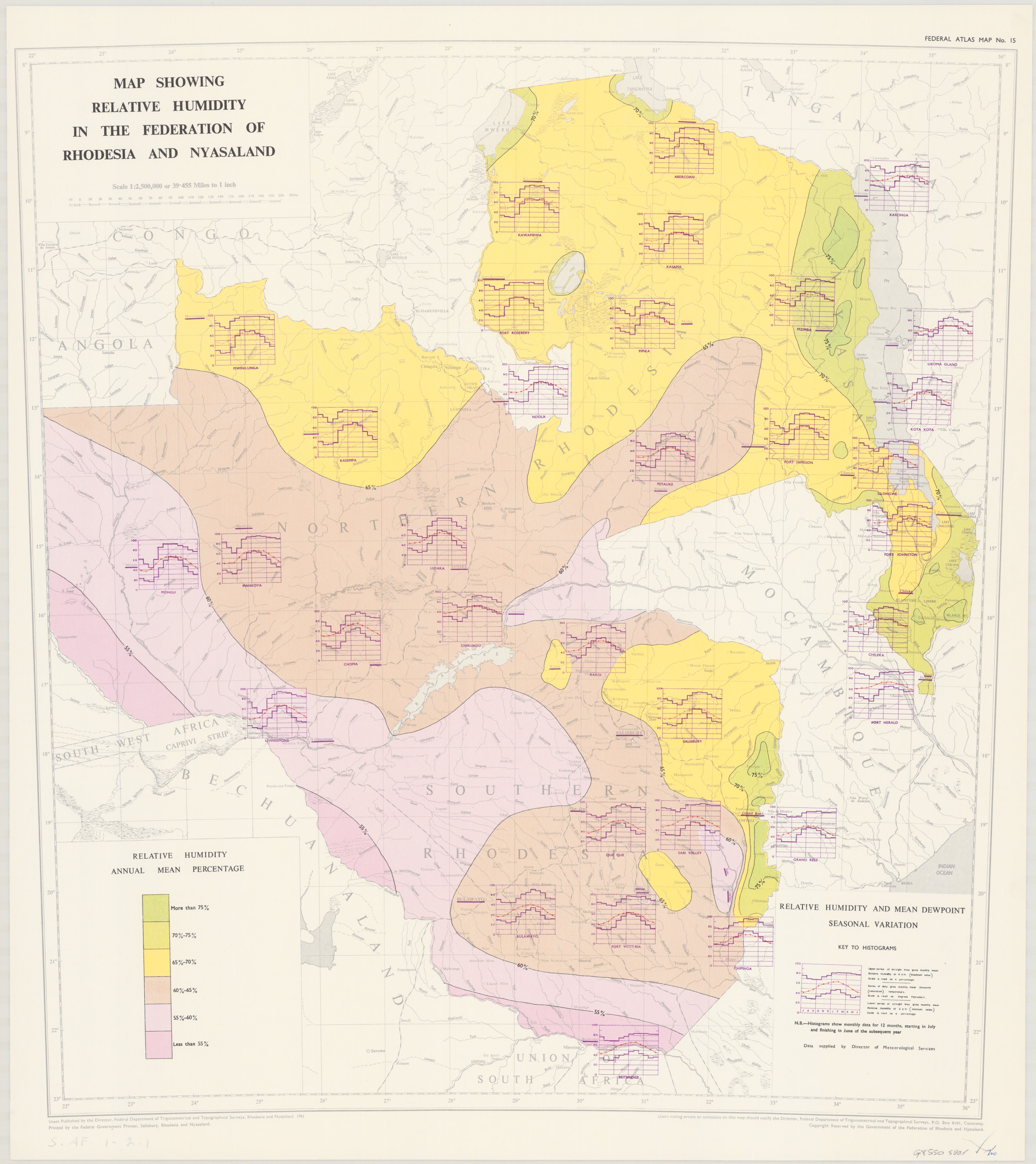
Details Federal atlas map: [Federation of Rhodesia and Nyasaland], Map 15. Title: Map showing relative humidity in the Federation of Rhodesia and Nyasaland. Scale: 1:2,500,000. Date: 1961. Format: JPG Size: 14 mb |
|
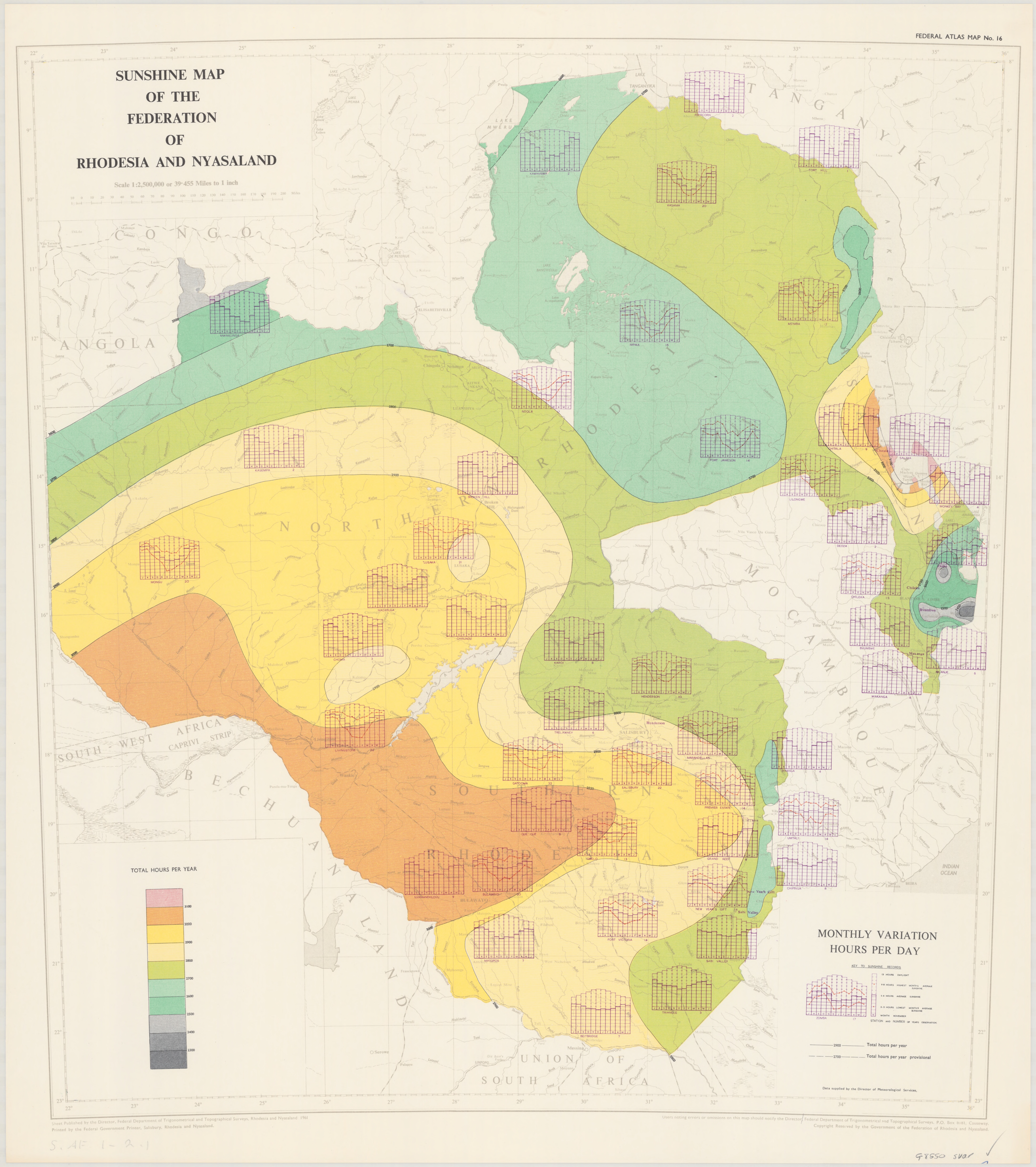
Details Federal atlas map: [Federation of Rhodesia and Nyasaland], Map 16. Title: Sunshine map of the Federation of Rhodesia and Nyasaland. Scale: 1:2,500,000. Date: 1961. Format: JPG Size: 14 mb |
|
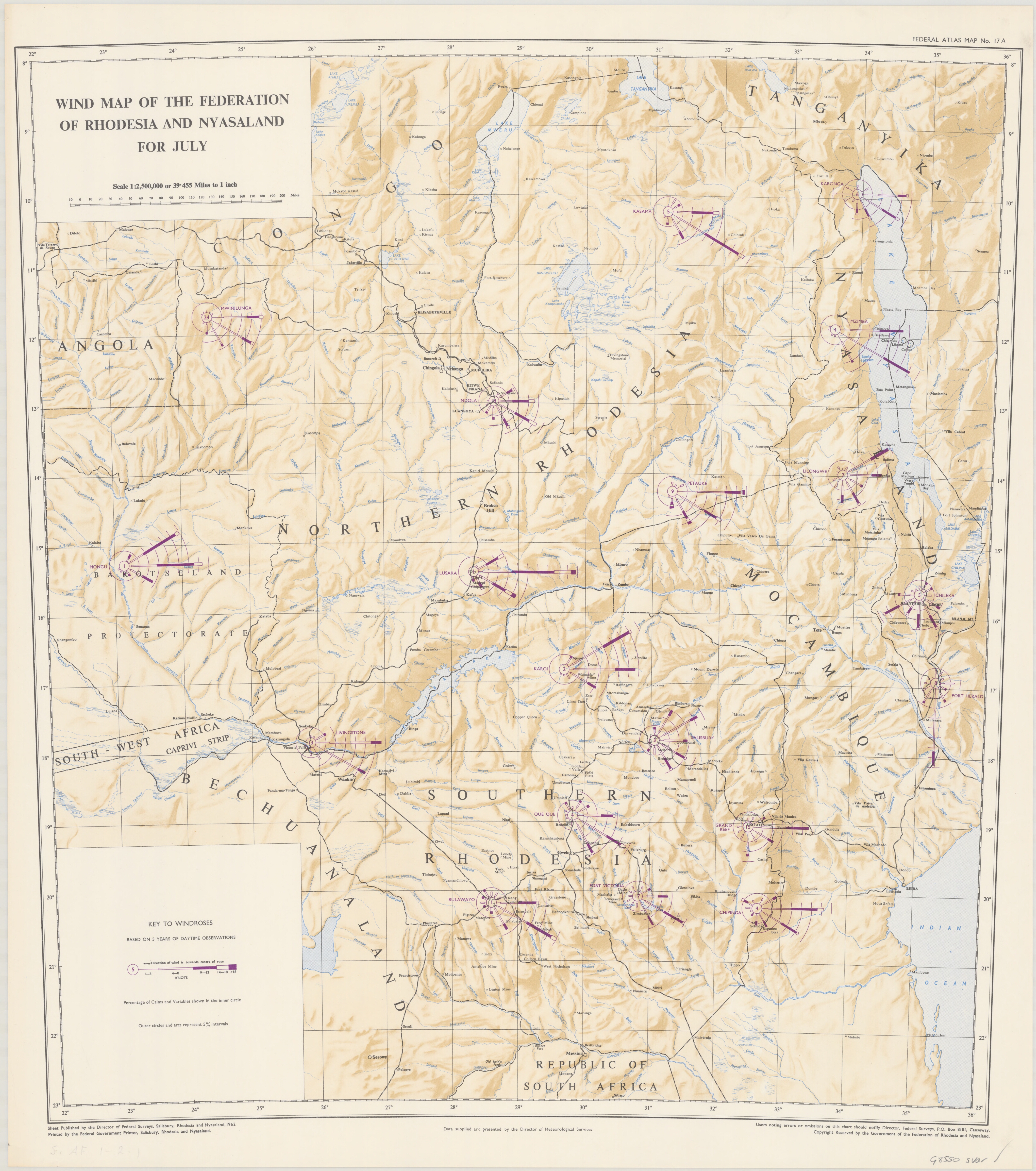
Details Federal atlas map: [Federation of Rhodesia and Nyasaland], Map 17A. Title: Wind map of the Federation of Rhodesia and Nyasaland for July. Scale: 1:2,500,000. Date: 1962. Format: JPG Size: 15 mb |
|
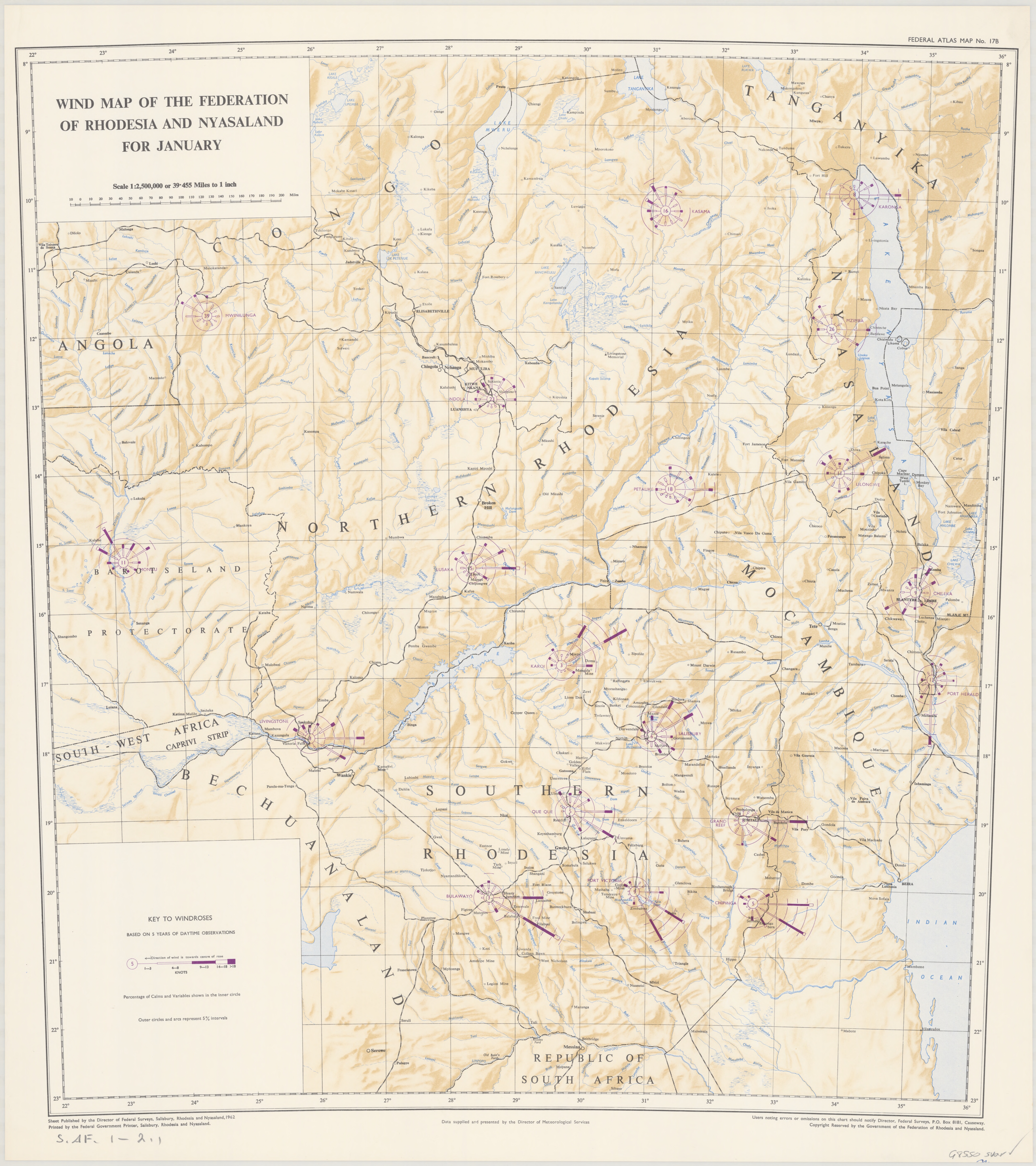
Details Federal atlas map: [Federation of Rhodesia and Nyasaland], Map 17B. Title: Wind map of the Federation of Rhodesia and Nyasaland for January. Scale: 1:2,500,000. Date: 1962. Format: JPG Size: 15 mb |
|
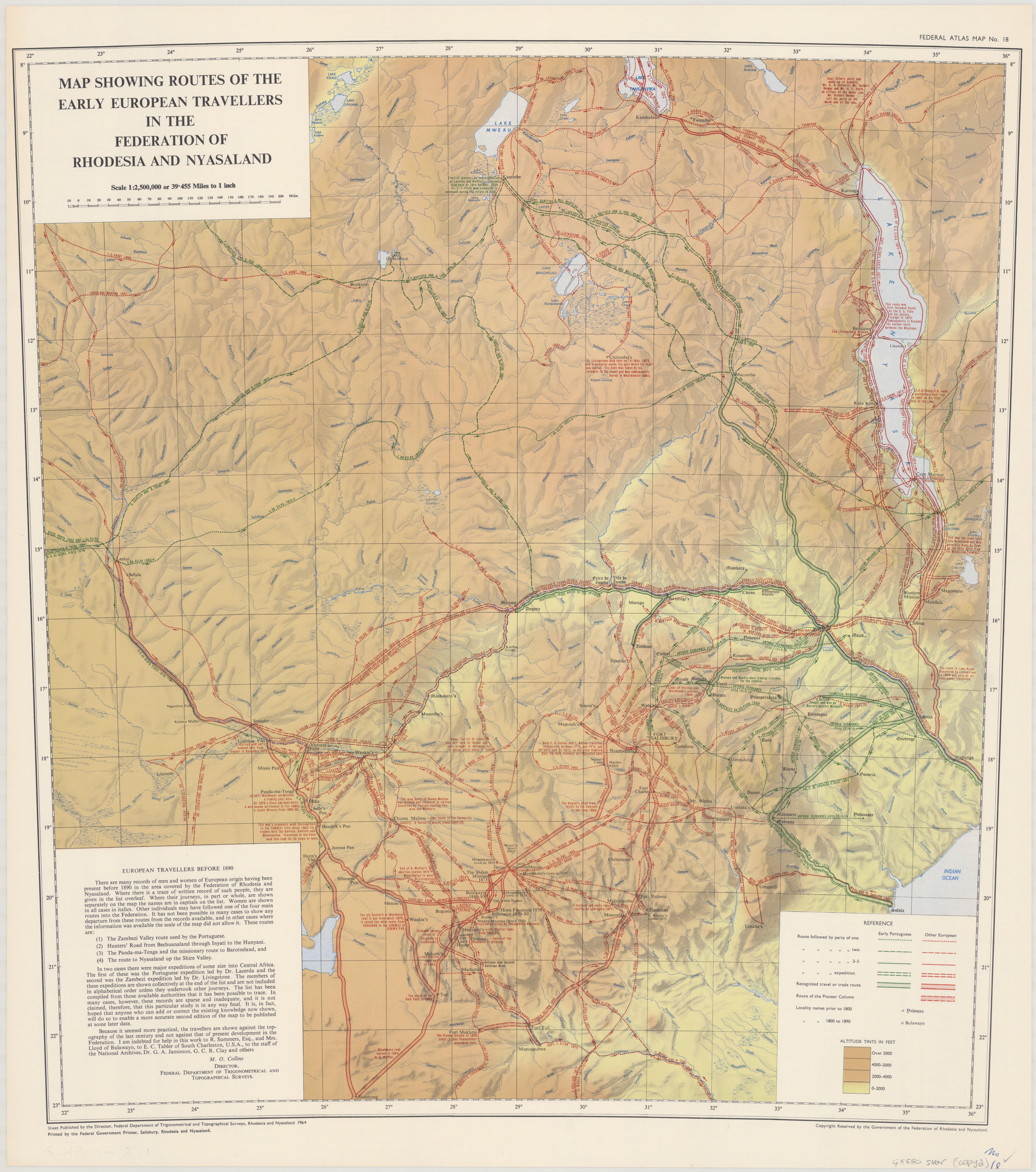
Details Federal atlas map: [Federation of Rhodesia and Nyasaland], Map 18. Title: Map showing the routes of the early European travellers in the Federation of Rhodesia and Nyasaland. Scale: 1:2,500,000. Date: 1964. Format: JPG Size: 16.5 mb |
|
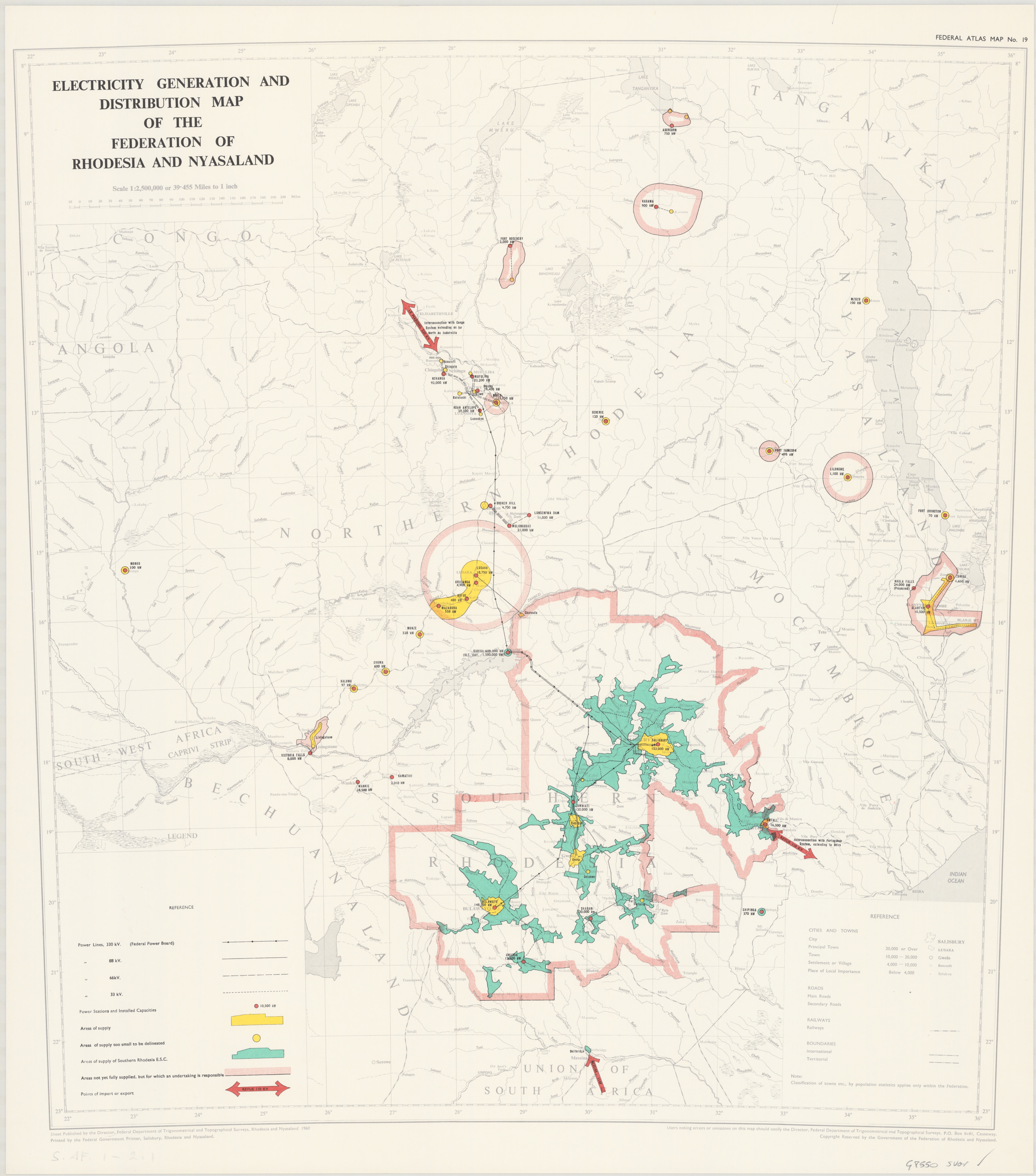
Details Federal atlas map: [Federation of Rhodesia and Nyasaland], Map 19. Title: Electricity generation and distribution map of the Federation of Rhodesia and Nyasaland. Scale: 1:2,500,000. Date: 1960. Format: JPG Size: 12 mb |
|
Details Federal atlas map: [Federation of Rhodesia and Nyasaland], Map 20. Title: Tobacco production map of the Federation of Rhodesia and Nyasaland. Scale: 1:2,500,000. Date: 1961. Format: JPG Size: 15 mb |
|
Details Source: VFB Bibliographisches Institut Leipzig (DDR) Title: AFRIKA Date: 1950s. Original dimensions: 15.5 x 23 cm Format: JPEG Size: 17.6 mb Notes: German language map of Africa. |
|
Details Source: VFB Bibliographisches Institut Leipzig (DDR) Title: AFRIKA - Wirtschaft (Economy) Date: 1950s. Original dimensions: 15.5 x 23 cm Format: JPEG Size: 19.2 mb Notes: German language map of Africa showing Economy of countries. |
|
|
Details Source: VFB Bibliographisches Institut Leipzig (DDR) Title: AFRIKA - Wirtschaft (Economy) Date: 1950s. Original dimensions: 15.5 x 23 cm Format: JPEG Size: 19.2 mb Notes: German language map of Africa showing Economy of countries. |